Search for the training you need
At Geoinfotech, we’re committed to supporting your training in geoinformatics and related technologies.
Whether you’re brand-new to ArcGIS, Drone, Surveying and Mapping or a seasoned GIS professional who wants to master the latest technology, we have resources to help you achieve your goals

Physical Training
At Geoinfotech we offer extensive hands-on practical training and field experience for individuals, group or for organizations. Register to explore our courses on Drone, GIS, Remote Sensing, GPS, Python development, advanced analysis tools, and many more.

Online Traning
Explore Geoinfotech's online training platform, at home or anywhere you are on Drone, GIS, Remote Sensing, GPS, Python development, advanced analysis tools, and many more. We have developed our online platform to be responsive for easy navigation and professionally recorded for better understanding.

Lagos State embraces technology for city transformation.
Lagos GIS transformation The Lagos State Government has begun move to embrace digital...
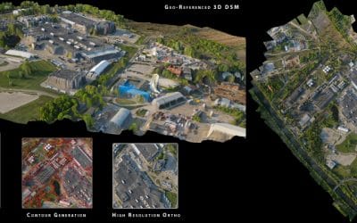
Drone Service provider in Nigeria
Nigeria drone data provider Contact us Geoinfotech is a leading provider of unmanned aircraft...

National Information Technology Development agency advices IoT(internet of things) in managing Coronavirus pandemic.
The National Information Technology Development Agency (NITDA) is a Federal Government Agency...
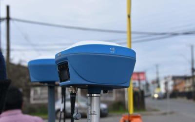
Achieve Surveying Excellence with the Tersus Oscar Ultimate Base and Rover GNSS RTK Receiver
Nigeria’s surveyors, engineers, and geospatial professionals demand cutting-edge tools for...

Master Precision Surveying with the Tersus Oscar Basic Base and Ultimate Rover GNSS RTK Receiver
For Nigeria’s surveyors, engineers, and geospatial experts, the Tersus Oscar Basic Base and...
Precision Surveying with the Tersus Oscar Basic GNSS RTK Receiver
For Nigeria’s surveyors, engineers, and geospatial professionals, the Tersus Oscar Basic GNSS RTK...
SERVICE LIST
We take your industry to the next level. Support Service Geoinfotech

Drone (Survey, Inspection, Surveillance, and Mapping)

Geographic Information System

Land Surveying

Remote Sensing and Satellite Mapping

Hydrographic Survey (Bathymetry)

Geophysical Survey

Training (Beginners to Advance / Professional)

GeoStore (Buy Products) Hardware / Software