Search for the training you need
At Geoinfotech, we’re committed to supporting your training in geoinformatics and related technologies.
Whether you’re brand-new to ArcGIS, Drone, Surveying and Mapping or a seasoned GIS professional who wants to master the latest technology, we have resources to help you achieve your goals

Physical Training
At Geoinfotech we offer extensive hands-on practical training and field experience for individuals, group or for organizations. Register to explore our courses on Drone, GIS, Remote Sensing, GPS, Python development, advanced analysis tools, and many more.

Online Traning
Explore Geoinfotech's online training platform, at home or anywhere you are on Drone, GIS, Remote Sensing, GPS, Python development, advanced analysis tools, and many more. We have developed our online platform to be responsive for easy navigation and professionally recorded for better understanding.
Drone Jobs in Nigeria
Drone Jobs in Nigeria You bring the skill. and We'll make earning easy for you You can easily make...

Ekiti sign MoU to lay 606km broadband infrastructure.
Ekiti MoU infrastructure As part of the plan to develop the digital economy in Ekiti State, the...

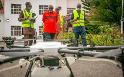
EKITI BEGINS DRONE, MOTORIZED FUMIGATION
Ekiti Government, has begun the fumigation of streets across the 16 local government areas...
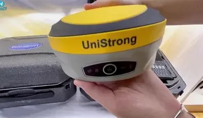
Precision Unleashed with the UniStrong G970II Pro Base and Rover GNSS RTK Receiver
For Nigeria’s surveyors, engineers, and geospatial experts, the UniStrong G970II Pro Base and...
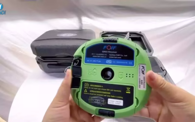
Precision Mapping with the FOIF A90 GNSS RTK Receiver
For Nigeria’s surveyors, engineers, and geospatial professionals, the FOIF A90 GNSS RTK Receiver,...
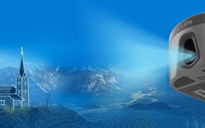
Elevate Your Surveying with the HI-TARGET VRTK GNSS RTK Receiver
For Nigeria’s surveyors, engineers, and geospatial professionals, the HI-TARGET VRTK GNSS RTK...
SERVICE LIST
We take your industry to the next level. Support Service Geoinfotech

Drone (Survey, Inspection, Surveillance, and Mapping)

Geographic Information System

Land Surveying

Remote Sensing and Satellite Mapping

Hydrographic Survey (Bathymetry)

Geophysical Survey

Training (Beginners to Advance / Professional)

GeoStore (Buy Products) Hardware / Software