Search for the training you need
At Geoinfotech, we’re committed to supporting your training in geoinformatics and related technologies.
Whether you’re brand-new to ArcGIS, Drone, Surveying and Mapping or a seasoned GIS professional who wants to master the latest technology, we have resources to help you achieve your goals

Physical Training
At Geoinfotech we offer extensive hands-on practical training and field experience for individuals, group or for organizations. Register to explore our courses on Drone, GIS, Remote Sensing, GPS, Python development, advanced analysis tools, and many more.

Online Traning
Explore Geoinfotech's online training platform, at home or anywhere you are on Drone, GIS, Remote Sensing, GPS, Python development, advanced analysis tools, and many more. We have developed our online platform to be responsive for easy navigation and professionally recorded for better understanding.

Esri launches ArcGIS platform
Esri launches ArcGIS platform Esri’s a location vendor, announces its launch of ArcGIS, a...
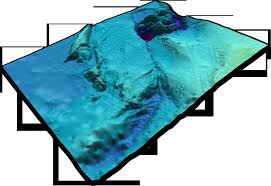
New vision of European bathymetry digital terrain model
The underwater depth of lake or ocean floor relative to sea level is referred to as Bathymetry....
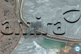
CGG joins mine tailings monitoring research project led by Amira
Amira Global is a member-based NFP enhancing, sustaining and delivering thought-leadership,...

How to Keep Your Drones Flying High: The Ultimate Guide to Drone Care and Performance
Drones have become indispensable tools across industries, from capturing aerial imagery for GIS...

How Drone-Based Remote Sensing Enhances Site Supervision in Nigeria
Efficient site supervision is the backbone of every successful construction project—especially in...

The Ethics of Disaster Mapping: Privacy, Consent, and Accuracy
In an era where drones soar, satellites capture, and algorithms analyze at lightning speed,...
SERVICE LIST
We take your industry to the next level. Support Service Geoinfotech

Drone (Survey, Inspection, Surveillance, and Mapping)

Geographic Information System

Land Surveying

Remote Sensing and Satellite Mapping

Hydrographic Survey (Bathymetry)

Geophysical Survey

Training (Beginners to Advance / Professional)

GeoStore (Buy Products) Hardware / Software