Search for the training you need
At Geoinfotech, we’re committed to supporting your training in geoinformatics and related technologies.
Whether you’re brand-new to ArcGIS, Drone, Surveying and Mapping or a seasoned GIS professional who wants to master the latest technology, we have resources to help you achieve your goals

Physical Training
At Geoinfotech we offer extensive hands-on practical training and field experience for individuals, group or for organizations. Register to explore our courses on Drone, GIS, Remote Sensing, GPS, Python development, advanced analysis tools, and many more.

Online Traning
Explore Geoinfotech's online training platform, at home or anywhere you are on Drone, GIS, Remote Sensing, GPS, Python development, advanced analysis tools, and many more. We have developed our online platform to be responsive for easy navigation and professionally recorded for better understanding.

Bluesky 3D building Models Drive Efficiency and Collaboration in Water Construction
The Bluesky 3D models provide us with a crucial understanding of locations we are working in,”...

Council uses drones to warn public to follow the coronavirus advice.
Staying aware of the most recent news on Coronavirus information by keeping to date from WHO and...

Robotic drone inspired by world’s fastest bird can replicate movements
Research shows that nature has been a source of inspiration over time, especially for the field of...
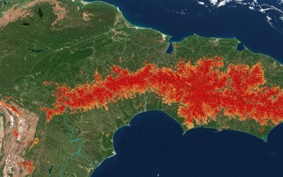
TRACKING DEFORESTATION OVER TIME USING LANDSAT DATA IN GOOGLE EARTH ENGINE
Forests are among Earth’s most vital ecosystems, but they’re vanishing at an alarming rate. From...
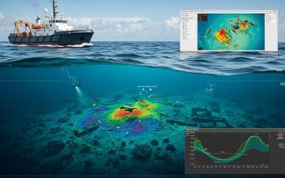
GIS in Bathymetric Surveys: Mapping the Hidden World Beneath Water
Digital Depth Model of a part of imo river in Akwa ibom State, Nigeria. In the vast world of...

Advanced Workflows with Blender GIS for Geospatial Professionals
Integrating High-Fidelity 3D Terrain, Vector Data, and Simulation in Blender As 3D geospatial...
SERVICE LIST
We take your industry to the next level. Support Service Geoinfotech

Drone (Survey, Inspection, Surveillance, and Mapping)

Geographic Information System

Land Surveying

Remote Sensing and Satellite Mapping

Hydrographic Survey (Bathymetry)

Geophysical Survey

Training (Beginners to Advance / Professional)

GeoStore (Buy Products) Hardware / Software