Search for the training you need
At Geoinfotech, we’re committed to supporting your training in geoinformatics and related technologies.
Whether you’re brand-new to ArcGIS, Drone, Surveying and Mapping or a seasoned GIS professional who wants to master the latest technology, we have resources to help you achieve your goals

Physical Training
At Geoinfotech we offer extensive hands-on practical training and field experience for individuals, group or for organizations. Register to explore our courses on Drone, GIS, Remote Sensing, GPS, Python development, advanced analysis tools, and many more.

Online Traning
Explore Geoinfotech's online training platform, at home or anywhere you are on Drone, GIS, Remote Sensing, GPS, Python development, advanced analysis tools, and many more. We have developed our online platform to be responsive for easy navigation and professionally recorded for better understanding.
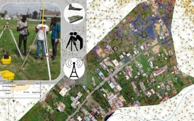
Topographic Surveying and Survey Plan services
Surveying Services in Nigeria Land Surveying is a technique used to make accurate measurements in...

Geospatial analytics companies
Geospatial analytical companies; Genesys International; Genesys International Corporation Ltd is a...

Amazon using drones
Amazon has unveiled the latest version of its Prime Air delivery drone, a hybrid aircraft that’s...

AI, Automation, and the Decades Ahead
Are Geospatial Experts Becoming Obsolete? What the Future Really Holds for Spatial Professionals...

Drones in Disaster Response and Recovery: Revolutionizing Crisis Management
When disaster strikes—whether it’s a hurricane, earthquake, or wildfire—every second counts....

Remote Sensing and Gis for Mineral Exploration
Discovering Hidden Treasures Beneath the Surface with Spatial Intelligence The quest for mineral...
SERVICE LIST
We take your industry to the next level. Support Service Geoinfotech

Drone (Survey, Inspection, Surveillance, and Mapping)

Geographic Information System

Land Surveying

Remote Sensing and Satellite Mapping

Hydrographic Survey (Bathymetry)

Geophysical Survey

Training (Beginners to Advance / Professional)

GeoStore (Buy Products) Hardware / Software