Search for the training you need
At Geoinfotech, we’re committed to supporting your training in geoinformatics and related technologies.
Whether you’re brand-new to ArcGIS, Drone, Surveying and Mapping or a seasoned GIS professional who wants to master the latest technology, we have resources to help you achieve your goals

Physical Training
At Geoinfotech we offer extensive hands-on practical training and field experience for individuals, group or for organizations. Register to explore our courses on Drone, GIS, Remote Sensing, GPS, Python development, advanced analysis tools, and many more.

Online Traning
Explore Geoinfotech's online training platform, at home or anywhere you are on Drone, GIS, Remote Sensing, GPS, Python development, advanced analysis tools, and many more. We have developed our online platform to be responsive for easy navigation and professionally recorded for better understanding.

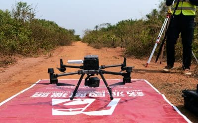
Geoinfotech Drone Mapping, Surveying and Inspection Services
Geoinfotech Drone Mapping, Surveying and Inspection Services Geoinfotech Resource Limited offers a...

How Geoinfotech relates cartography in GIS environment
How Geoinfotech relates cartography in the GIS environment Over the years, Geoinfotech relates...
The Esri Company
The Esri Company The founder and president of Esri, Jack Dangermond founded the Esri company in...
How Modern Land Surveying Guides Every Project in Lagos and Across Nigeria
If you’ve ever seen a new building rise, a road being constructed, or farmland divided for sale, a...

WASTE MANAGEMENT, URBAN FLOODING, AND THE HIDDEN ROLE OF GIS
In today’s rapidly urbanizing world, the challenges of managing solid waste and controlling urban...

Training the Next Generation: Why Public Health Students Need GIS Skills
In the age of big data and global health challenges, public health professionals are increasingly...
SERVICE LIST
We take your industry to the next level. Support Service Geoinfotech

Drone (Survey, Inspection, Surveillance, and Mapping)

Geographic Information System

Land Surveying

Remote Sensing and Satellite Mapping

Hydrographic Survey (Bathymetry)

Geophysical Survey

Training (Beginners to Advance / Professional)

GeoStore (Buy Products) Hardware / Software