Search for the training you need
At Geoinfotech, we’re committed to supporting your training in geoinformatics and related technologies.
Whether you’re brand-new to ArcGIS, Drone, Surveying and Mapping or a seasoned GIS professional who wants to master the latest technology, we have resources to help you achieve your goals

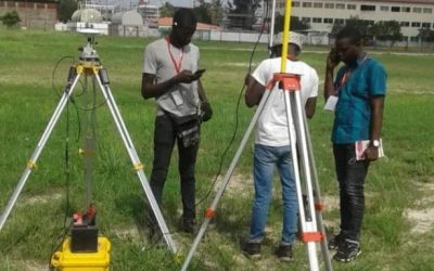
Physical Training
At Geoinfotech we offer extensive hands-on practical training and field experience for individuals, group or for organizations. Register to explore our courses on Drone, GIS, Remote Sensing, GPS, Python development, advanced analysis tools, and many more.

Online Traning
Explore Geoinfotech's online training platform, at home or anywhere you are on Drone, GIS, Remote Sensing, GPS, Python development, advanced analysis tools, and many more. We have developed our online platform to be responsive for easy navigation and professionally recorded for better understanding.

Drones deployed for news coverage in six states
Drones deployed for news coverage in six states For effective coverage of events, the News Agency...

Cloud-base GIS relation to Government
WHAT IS CLOUD-BASED GIS These are hosted vendor's servers and accessed through a browser...

The Impeding Progress of Land Tenure System
The Impeding Progress of Land Tenure System Mr. Taiwo Adeniran, Surveyor-General of the...

How DGNSS and Drone Surveying are Revolutionising Land Surveying and the Mining Industry
1. Introduction Surveying and mining are precision-driven industries where accuracy, efficiency,...
Land Surveying Fundamentals: Techniques, Tools, and Proven Best Practices
Land surveying is the scientific and systematic process of measuring and mapping the physical...

🌱 GIS in Agriculture Nigeria – Drone Mapping and Precision Farming Solutions
GIS in agriculture in Nigeria is transforming how farmers manage land, crops, and resources. By...
SERVICE LIST
We take your industry to the next level. Support Service Geoinfotech

Drone (Survey, Inspection, Surveillance, and Mapping)

Geographic Information System

Land Surveying

Remote Sensing and Satellite Mapping

Hydrographic Survey (Bathymetry)

Geophysical Survey

Training (Beginners to Advance / Professional)

GeoStore (Buy Products) Hardware / Software