Search for the training you need
At Geoinfotech, we’re committed to supporting your training in geoinformatics and related technologies.
Whether you’re brand-new to ArcGIS, Drone, Surveying and Mapping or a seasoned GIS professional who wants to master the latest technology, we have resources to help you achieve your goals

Physical Training
At Geoinfotech we offer extensive hands-on practical training and field experience for individuals, group or for organizations. Register to explore our courses on Drone, GIS, Remote Sensing, GPS, Python development, advanced analysis tools, and many more.

Online Traning
Explore Geoinfotech's online training platform, at home or anywhere you are on Drone, GIS, Remote Sensing, GPS, Python development, advanced analysis tools, and many more. We have developed our online platform to be responsive for easy navigation and professionally recorded for better understanding.
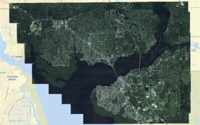
Aerial Imagery Helping Recovery from Hurricane IAN
Aerial Imagery Helping Recovery from Hurricane IAN Aerial Imagery Helping Recovery From Hurricane...

News From Geoinfotech October 1st Free Gis Training Workshop
News From Geoinfotech October 1st Free Gis Training Workshop News From Geoinfotech...

Court Invalidates Section 5 Of Lagos State Survey Law
COURT INVALIDATES SECTION 5 OF LAGOS STATE SURVEY LAW A Federal High Court sitting in...

How Geo-Innovation Is Driving Sustainable Development
Sustainable development has become a daily priority rather than a distant aspiration. As...

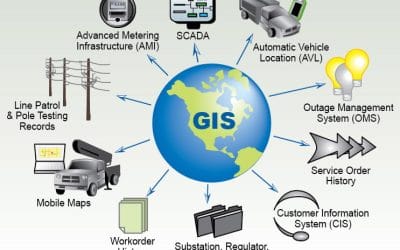
GEOGRAPHIC INFORMATION SYSTEM (GIS) AND GEOSPATIAL TECHNOLOGY IN NIGERIA
Introduction Geographic Information Systems (GIS) and geospatial technology continue to reshape...
UNDERSTANDING GIS AND GEOSPATIAL TECHNOLOGY
Introduction Geographic Information Systems (GIS) and Geospatial Technology are modern...
SERVICE LIST
We take your industry to the next level. Support Service Geoinfotech

Drone (Survey, Inspection, Surveillance, and Mapping)

Geographic Information System

Land Surveying

Remote Sensing and Satellite Mapping

Hydrographic Survey (Bathymetry)

Geophysical Survey

Training (Beginners to Advance / Professional)

GeoStore (Buy Products) Hardware / Software