Search for the training you need
At Geoinfotech, we’re committed to supporting your training in geoinformatics and related technologies.
Whether you’re brand-new to ArcGIS, Drone, Surveying and Mapping or a seasoned GIS professional who wants to master the latest technology, we have resources to help you achieve your goals

Physical Training
At Geoinfotech we offer extensive hands-on practical training and field experience for individuals, group or for organizations. Register to explore our courses on Drone, GIS, Remote Sensing, GPS, Python development, advanced analysis tools, and many more.

Online Traning
Explore Geoinfotech's online training platform, at home or anywhere you are on Drone, GIS, Remote Sensing, GPS, Python development, advanced analysis tools, and many more. We have developed our online platform to be responsive for easy navigation and professionally recorded for better understanding.

PMS Price Dashboard Nigeria: How GIS is Transforming Fuel Price Monitoring (Geostore)
Tracking PMS Prices in Nigeria: How Geostore’s GIS Dashboard Brings Transparency to the Petroleum...

Revolutionizing Mineral Prospectivity Mapping in Nigeria Using Google Earth Engine (Geostore Guide)
Revolutionizing Mineral Prospectivity Mapping in Nigeria Using Google Earth Engine | Geostore...
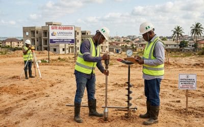
Why Every Real Estate Developer in Nigeria Must Do a Soil Test Before Buying Land
Why Every Real Estate Developer in Nigeria Should Do a Soil Test Before Buying Land Imagine...
PMS Price Dashboard Nigeria: How GIS is Transforming Fuel Price Monitoring (Geostore)
Tracking PMS Prices in Nigeria: How Geostore’s GIS Dashboard Brings Transparency to the Petroleum...
Revolutionizing Mineral Prospectivity Mapping in Nigeria Using Google Earth Engine (Geostore Guide)
Revolutionizing Mineral Prospectivity Mapping in Nigeria Using Google Earth Engine | Geostore...
Mineral Prospectivity Mapping in Nigeria Using Google Earth Engine & Real-Time Geospatial Intelligence
Transforming Nigeria’s Mining Sector: The Power of Geoinfotech’s New Mineral Exploration Web App...
SERVICE LIST
We take your industry to the next level. Support Service Geoinfotech

Drone (Survey, Inspection, Surveillance, and Mapping)

Geographic Information System

Land Surveying

Remote Sensing and Satellite Mapping

Hydrographic Survey (Bathymetry)

Geophysical Survey

Training (Beginners to Advance / Professional)

GeoStore (Buy Products) Hardware / Software