Search for the training you need
At Geoinfotech, we’re committed to supporting your training in geoinformatics and related technologies.
Whether you’re brand-new to ArcGIS, Drone, Surveying and Mapping or a seasoned GIS professional who wants to master the latest technology, we have resources to help you achieve your goals

Physical Training
At Geoinfotech we offer extensive hands-on practical training and field experience for individuals, group or for organizations. Register to explore our courses on Drone, GIS, Remote Sensing, GPS, Python development, advanced analysis tools, and many more.

Online Traning
Explore Geoinfotech's online training platform, at home or anywhere you are on Drone, GIS, Remote Sensing, GPS, Python development, advanced analysis tools, and many more. We have developed our online platform to be responsive for easy navigation and professionally recorded for better understanding.
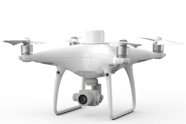
Where to Buy DJI Phantom 4 RTK with D-RTK 2 in Lagos, Nigeria
Where to Buy DJI Phantom 4 RTK with D-RTK 2 Mobile Station in Lagos, Nigeria (2026 Guide) If you...
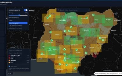
Nigeria Flood Prediction Dashboard: Building a Smarter Way to Monitor Flood Risk
Flooding remains one of the most disruptive environmental hazards in Nigeria. It affects lives,...
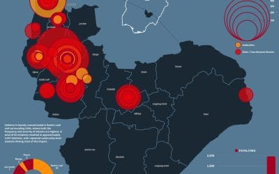
Violence in Jos, Plateau State (2020–2026): Trends, Hotspots, and Fatality Patterns
Introduction Violence in Jos, Plateau State has remained a persistent security challenge, with...
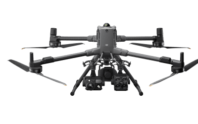
What is the Best Drone for Mapping Eko Atlantic? (Matrice 4E vs. Matrice 400)
Mapping a high-value, fast-developing area like Eko Atlantic City in Lagos requires precision,...

PMS Price Intelligence: Transforming Fuel Monitoring in Nigeria with Geospatial Analytics
Navigating the downstream petroleum sector in Nigeria has always been a challenge due to one...

Revolutionizing Nigerian Infrastructure Security: GEOSTORE’s Real-Time Drone Surveillance System
Operational monitoring of critical infrastructure such as oil pipelines, wellheads, and remote...
SERVICE LIST
We take your industry to the next level. Support Service Geoinfotech

Drone (Survey, Inspection, Surveillance, and Mapping)

Geographic Information System

Land Surveying

Remote Sensing and Satellite Mapping

Hydrographic Survey (Bathymetry)

Geophysical Survey

Training (Beginners to Advance / Professional)

GeoStore (Buy Products) Hardware / Software