Search for the training you need
At Geoinfotech, we’re committed to supporting your training in geoinformatics and related technologies.
Whether you’re brand-new to ArcGIS, Drone, Surveying and Mapping or a seasoned GIS professional who wants to master the latest technology, we have resources to help you achieve your goals

Physical Training
At Geoinfotech we offer extensive hands-on practical training and field experience for individuals, group or for organizations. Register to explore our courses on Drone, GIS, Remote Sensing, GPS, Python development, advanced analysis tools, and many more.

Online Traning
Explore Geoinfotech's online training platform, at home or anywhere you are on Drone, GIS, Remote Sensing, GPS, Python development, advanced analysis tools, and many more. We have developed our online platform to be responsive for easy navigation and professionally recorded for better understanding.
Where to Buy DJI Matrice 4TD Thermal Drone for Dock 3 in Lagos Nigeria | Price & Trusted Supplier
Where to Buy a DJI Matrice 4TD Thermal Drone for Dock 3 in Lagos, Nigeria If you're searching for...
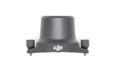
Where to Buy DJI Mavic 3 Enterprise RTK Module in Lagos Nigeria (Price & Trusted Dealers 2026)
Where to Buy DJI Mavic 3 Enterprise Series RTK Module in Lagos, Nigeria (2026 Guide) If you are...
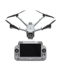
Where to Buy DJI Mavic 3 Pro Fly More Combo + RC in Lagos, Nigeria
Where to Buy DJI Mavic 3 Pro Fly More Combo + RC in Lagos, Nigeria (2026 Guide) If you’re...
Where to Buy DJI Mavic 3 Enterprise RTK Module in Lagos Nigeria (Price & Trusted Dealers 2026)
Where to Buy DJI Mavic 3 Enterprise Series RTK Module in Lagos, Nigeria (2026 Guide) If you are...
Where to Buy DJI Mavic 3 Pro Cine Premium Combo in Lagos, Nigeria (2026 Guide)
Where to Buy DJI Mavic 3 Pro Cine Premium Combo in Lagos, Nigeria (2026 Guide) If you’re searching...
Where to Buy DJI Mavic 3 Pro Fly More Combo + RC in Lagos, Nigeria
Where to Buy DJI Mavic 3 Pro Fly More Combo + RC in Lagos, Nigeria (2026 Guide) If you’re...
SERVICE LIST
We take your industry to the next level. Support Service Geoinfotech

Drone (Survey, Inspection, Surveillance, and Mapping)

Geographic Information System

Land Surveying

Remote Sensing and Satellite Mapping

Hydrographic Survey (Bathymetry)

Geophysical Survey

Training (Beginners to Advance / Professional)

GeoStore (Buy Products) Hardware / Software