Search for the training you need
At Geoinfotech, we’re committed to supporting your training in geoinformatics and related technologies.
Whether you’re brand-new to ArcGIS, Drone, Surveying and Mapping or a seasoned GIS professional who wants to master the latest technology, we have resources to help you achieve your goals

Physical Training
At Geoinfotech we offer extensive hands-on practical training and field experience for individuals, group or for organizations. Register to explore our courses on Drone, GIS, Remote Sensing, GPS, Python development, advanced analysis tools, and many more.

Online Traning
Explore Geoinfotech's online training platform, at home or anywhere you are on Drone, GIS, Remote Sensing, GPS, Python development, advanced analysis tools, and many more. We have developed our online platform to be responsive for easy navigation and professionally recorded for better understanding.
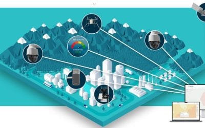
BRINGING FIELD DATA TO THE WEB IN NIGERIA
Field-based data collection has always been a crucial component of environmental studies, urban...
What is GIS? A Beginner’s Guide to Geographic Information Systems
What is GIS? Geographic Information Systems (GIS) have become one of the most powerful tools of...
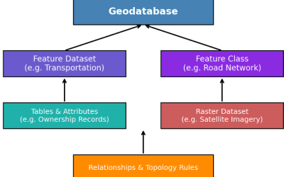
Inside a GeoDatabase: Organising Spatial Data for Faster Results in Nigeria
The increasing demand for geospatial information in Nigeria has transformed how data is collected,...

How to Become a Certified Drone Pilot in Nigeria: Step-by-Step Guide
Drones are no longer just for photography enthusiasts—they have become vital tools in agriculture,...
What is GIS? A Beginner’s Guide to Geographic Information Systems
What is GIS? Geographic Information Systems (GIS) have become one of the most powerful tools of...

Land Surveyors in Nigeria
Buying land in Nigeria is a big investment. Whether you’re planning to build a home, start a...
SERVICE LIST
We take your industry to the next level. Support Service Geoinfotech

Drone (Survey, Inspection, Surveillance, and Mapping)

Geographic Information System

Land Surveying

Remote Sensing and Satellite Mapping

Hydrographic Survey (Bathymetry)

Geophysical Survey

Training (Beginners to Advance / Professional)

GeoStore (Buy Products) Hardware / Software