
Search for the training you need
At Geoinfotech, we’re committed to supporting your training in geoinformatics and related technologies.
Whether you’re brand-new to ArcGIS, Drone, Surveying and Mapping or a seasoned GIS professional who wants to master the latest technology, we have resources to help you achieve your goals

Physical Training
At Geoinfotech we offer extensive hands-on practical training and field experience for individuals, group or for organizations. Register to explore our courses on Drone, GIS, Remote Sensing, GPS, Python development, advanced analysis tools, and many more.

Online Training
Explore Geoinfotech's online training platform, at home or anywhere you are on Drone, GIS, Remote Sensing, GPS, Python development, advanced analysis tools, and many more. We have developed our online platform to be responsive for easy navigation and professionally recorded for better understanding.
SERVICE LIST
We take your industry to the next level. Support Service Geoinfotech

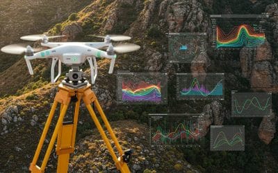
Drone (Survey, Inspection, Surveillance, and Mapping)

Geographic Information System

Land Surveying

Remote Sensing and Satellite Mapping

Hydrographic Survey (Bathymetry)

Geophysical Survey

Training (Beginners to Advance / Professional)

GeoStore (Buy Products) Hardware / Software

New Roadmap and KPIs unfold as Pantami engages NIGCOMSAT
New Roadmaps and KPIs unfold as Pantami engages NIGCOMSAT New Roadmap and KPIs unfold as Pantami...

Millions of Nigerians will migrate due to climate change – World Bank
The world bank has revealed that low agricultural production, water scarcity, rising sea levels,...

Nigerian Navy Bridging Maritime Security Gaps: The Last Five Years
The Nigerian Navy has In line with its statutory mandate, in the past five years under the...

Remote Sensing and Gis for Mineral Exploration
Discovering Hidden Treasures Beneath the Surface with Spatial Intelligence The quest for mineral...
The Interrelationship of Surveying, Geospatial Analysis, and Drone Technology.
In an era where location data has become central to decision-making, infrastructure planning, and...

Topology in GIS: Beyond Geometry — Understanding Spatial Relationships
In the world of Geographic Information Systems (GIS), geometry may be the star of the show—but...