
Search for the training you need
At Geoinfotech, we’re committed to supporting your training in geoinformatics and related technologies.
Whether you’re brand-new to ArcGIS, Drone, Surveying and Mapping or a seasoned GIS professional who wants to master the latest technology, we have resources to help you achieve your goals

Physical Training
At Geoinfotech we offer extensive hands-on practical training and field experience for individuals, group or for organizations. Register to explore our courses on Drone, GIS, Remote Sensing, GPS, Python development, advanced analysis tools, and many more.

Online Training
Explore Geoinfotech's online training platform, at home or anywhere you are on Drone, GIS, Remote Sensing, GPS, Python development, advanced analysis tools, and many more. We have developed our online platform to be responsive for easy navigation and professionally recorded for better understanding.
SERVICE LIST
We take your industry to the next level. Support Service Geoinfotech

Drone (Survey, Inspection, Surveillance, and Mapping)

Geographic Information System

Land Surveying

Remote Sensing and Satellite Mapping

Hydrographic Survey (Bathymetry)

Geophysical Survey

Training (Beginners to Advance / Professional)

GeoStore (Buy Products) Hardware / Software

Governor Ortom affirms 6Billion GIS-Project completion
Governor Samuel Ortom affirms 6Billion GIS-Project completion before the mid of the year, named...

Pantami affirms Launch of Second Satellite
In the quest to launch a second satellite (Sat 2) into orbit, Nigeria has mapped out strategies to...

Drones deployed for news coverage in six states
Drones deployed for news coverage in six states For effective coverage of events, the News Agency...
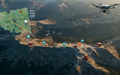
How GIS is Revolutionizing Search and Rescue (SAR) Missions
Using Spatial Intelligence to Save Lives in Real Time. In critical moments when disaster...

The Power of Spatial Thinking: How GIS Drives Smart Decision-Making Across Sectors
In a world overflowing with data and facing increasingly complex challenges — from climate change...
Working with Raster Data in QGIS – Series 5
Raster data forms a core part of spatial analysis from satellite imagery to digital elevation...