
Search for the training you need
At Geoinfotech, we’re committed to supporting your training in geoinformatics and related technologies.
Whether you’re brand-new to ArcGIS, Drone, Surveying and Mapping or a seasoned GIS professional who wants to master the latest technology, we have resources to help you achieve your goals

Physical Training
At Geoinfotech we offer extensive hands-on practical training and field experience for individuals, group or for organizations. Register to explore our courses on Drone, GIS, Remote Sensing, GPS, Python development, advanced analysis tools, and many more.

Online Training
Explore Geoinfotech's online training platform, at home or anywhere you are on Drone, GIS, Remote Sensing, GPS, Python development, advanced analysis tools, and many more. We have developed our online platform to be responsive for easy navigation and professionally recorded for better understanding.
SERVICE LIST
We take your industry to the next level. Support Service Geoinfotech

Drone (Survey, Inspection, Surveillance, and Mapping)

Geographic Information System

Land Surveying

Remote Sensing and Satellite Mapping

Hydrographic Survey (Bathymetry)

Geophysical Survey

Training (Beginners to Advance / Professional)

GeoStore (Buy Products) Hardware / Software

Geographic Information in Agriculture
What is GIS in agriculture, and why does it matter? Faces of GIS in Sustainable Agriculture...

COMPANIES TO CONSULT ON LAND MATTERS
Land matters in Nigeria can be very complicated, involving issues like property disputes and...
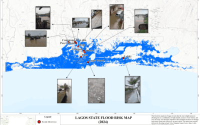
Understanding Flood Risk in Lagos: Causes, Impact, and Solutions
Introduction Flooding is a significant environmental and socioeconomic issue affecting many parts...

Top Mapping Techniques Every Surveyor Should Know
In today’s fast-evolving geospatial world, precision, speed, and reliability are non-negotiable....

How Geo-Innovation Is Driving Sustainable Development
Sustainable development has become a daily priority rather than a distant aspiration. As...

GEOGRAPHIC INFORMATION SYSTEM (GIS) AND GEOSPATIAL TECHNOLOGY IN NIGERIA
Introduction Geographic Information Systems (GIS) and geospatial technology continue to reshape...