

Search for the training you need
At Geoinfotech, we’re committed to supporting your training in geoinformatics and related technologies.
Whether you’re brand-new to ArcGIS, Drone, Surveying and Mapping or a seasoned GIS professional who wants to master the latest technology, we have resources to help you achieve your goals

Physical Training
At Geoinfotech we offer extensive hands-on practical training and field experience for individuals, group or for organizations. Register to explore our courses on Drone, GIS, Remote Sensing, GPS, Python development, advanced analysis tools, and many more.

Online Training
Explore Geoinfotech's online training platform, at home or anywhere you are on Drone, GIS, Remote Sensing, GPS, Python development, advanced analysis tools, and many more. We have developed our online platform to be responsive for easy navigation and professionally recorded for better understanding.
SERVICE LIST
We take your industry to the next level. Support Service Geoinfotech

Drone (Survey, Inspection, Surveillance, and Mapping)

Geographic Information System

Land Surveying

Remote Sensing and Satellite Mapping

Hydrographic Survey (Bathymetry)

Geophysical Survey

Training (Beginners to Advance / Professional)

GeoStore (Buy Products) Hardware / Software
Effektive Lösungen für Unternehmen mit Incaspin und intelligenter Prozessoptimierung
Effektive Lösungen für Unternehmen mit Incaspin und intelligenter ProzessoptimierungDie Bedeutung...
Análisis exhaustivo de tendencias y oportunidades con grana-wins.mx para un crecimiento financiero sostenible
Análisis exhaustivo de tendencias y oportunidades con grana-wins.mx para un crecimiento financiero...
Vielfältige Gewinnchancen mit https://coins-games.de für erfahrene Spieler erleben
Vielfältige Gewinnchancen mit https://coins-games.de für erfahrene Spieler erlebenDie Vielfalt der...

How to Get Accurate Topographic Maps for Lagos Urban Planning (2026 Professional Guide)
Whether you are an urban planner, a civil engineer, or a real estate developer, navigating the...
How to Get Accurate Topographic Maps for Lagos Urban Planning (2026 Professional Guide)
Whether you are an urban planner, a civil engineer, or a real estate developer, navigating the...
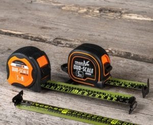
How to Maintain and Calibrate Survey Equipment in Nigeria’s Climate (2026 Guide)
In the high-stakes world of Nigerian construction and real estate, accuracy is your currency....