REMOTE SENSING ELEMENTS EXPOSITORY Elements of Remote Sensing Remote Sensing Elements...


YOU MAY ALSO LIKE...
REMOTE SENSING ELEMENTS EXPOSITORY Elements of Remote Sensing Remote Sensing Elements...

IMPORTANCE OF REMOTELY SENSED SATELLITE DATA AND IMAGES Introduction Remotely sensed...

Top Remote Sensing Training Centres in Lagos, Abuja, and Port Harcourt. How to Find the Right...

Georeferencing Satellite Imagery Georeferencing is one of the most important processes in GIS...
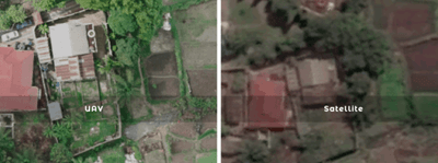
Drone Mapping vs Satellite Imagery: Which is Better? In the world of GIS, remote sensing,...

Drone Survey Services in Akwa Ibom State At Geoinfotech, we provide professional drone survey...