Mapping a high-value, fast-developing area like Eko Atlantic City in Lagos requires precision,...


YOU MAY ALSO LIKE...
Mapping a high-value, fast-developing area like Eko Atlantic City in Lagos requires precision,...

Navigating the downstream petroleum sector in Nigeria has always been a challenge due to one...

Operational monitoring of critical infrastructure such as oil pipelines, wellheads, and remote...
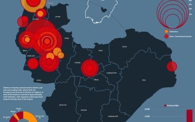
Introduction Violence in Jos, Plateau State has remained a persistent security challenge, with...

Tracking PMS Prices in Nigeria: How Geostore’s GIS Dashboard Brings Transparency to the Petroleum...

Revolutionizing Mineral Prospectivity Mapping in Nigeria Using Google Earth Engine | Geostore...