404
Oops!, that page can’t be found.
There are other options that might interest you below
Oops!, that page can’t be found.
There are other options that might interest you below
Search Results
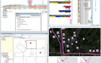
GIS Telecommunication In Nigeria
INTRODUCTIONGeographic Information System (GIS) has grown rapidly, and it is applied in different industries. In time past, Geoinfotech has gathered numerous forms of information systems, for telecommunication companies in Nigeria some of which were developed...
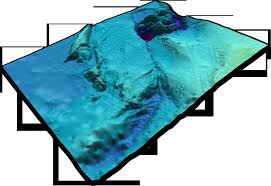
New vision of European bathymetry digital terrain model
The underwater depth of lake or ocean floor relative to sea level is referred to as Bathymetry. Which comprises of a geospatial framework equivalent to land topography and therefore constitutes a critical boundary condition for geophysical, geological, biological, and...
CGG joins mine tailings monitoring research project led by Amira
Amira Global is a member-based NFP enhancing, sustaining and delivering thought-leadership, building collaboration, and accelerating commercialization. CGG’s Minerals & Mining group is sponsoring a mine tailing monitoring research project after becoming a member...

Geographic Information System (GIS) Software.
GIS Software A Geographic Information System (GIS Software) is designed to store, retrieve, manage and analyze all types of geographic and spatial data. GIS software lets you produce maps and other graphic displays of geographic information for analysis and...
Evolution of GIS.
GIS has evolved from a concept to a science. The phenomenal evolution of GIS from a crude tool to a modern, powerful platform for understanding and planning our world is marked by several key milestones. The field of geographic information systems (GIS) started in the...

Drone Surveying, Mapping and Inspection Service in Nigeria
Drone Service in Nigeria We capture, analyze and map aerial data quickly and cost-effective in Nigeria, with leading Drone technology to help industries and professionals transform real-world scenarios into digital assets. We perform the following services under...
GIS Company in Nigeria
Our organisation is committed to satisfying our clients in developing quality service and innovative technological application that works in Nigeria We create maps of different kinds with a good cartographic layout and precise coordinate reference GIS Geodatabase...

GIS Programming: What is Spatial Analysis?
Spatial analysis can be done using various techniques with the aid of statistics and geographical information systems (GIS). A GIS facilitates attribute interaction with geographical data in order to enhance interpretation accuracy and prediction of spatial analysis....
GIS Programming : QGIS Software
QGIS functions as geographic information system (GIS) software, thereby allowing users to analyze and edit spatial information, in addition to composing and exporting graphical maps. QGIS also described as Quantum GIS is a free and open-source cross-platform desktop...
CONTACT US