404
Oops!, that page can’t be found.
There are other options that might interest you below
Oops!, that page can’t be found.
There are other options that might interest you below
Search Results

TACKLING INSURGENCY USING DRONE TECHNOLOGY
In tackling insurgency using drone technology. The Surveyor-General of the federation Abdul Ganiyu Adebomehin, while addressing journalists in Abuja yesterday, says his office has been able to purchase the latest drones technology and other equipment used in mapping...

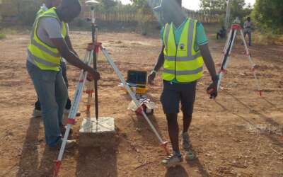
Aerial imagery Land Surveying Company
We choose to work with up-to-date trends of technology because it is fast replacing humans in many sectors by providing better and more efficient alternatives. This is why we as an aerial imagery land surveying company, offer the best commercially available imagery...

Stakeholders charge FG following illicit surveys
Stakeholders charge FG following illicit surveys, which violates the rules and regulations guiding survey works across the country. Hence, following the Survey Coordination Act 1962 will foster other sectors, to work towards progress and a sustainable economy. Thereby...

REMOTE SENSING FOR ACCURATE TRANSMISSION LINES
It’s usually a delight to enjoy steady electricity for the daily running of businesses and incorporating remote sensing for accurate transmission lines is a head start. The best efficient way we tackle this at Geoinfotech is to effectively monitor and maintain power...
Surveying company in Lagos, Abuja Nigeria
Geoinfotech Surveying company in Lagos, Abuja Nigeria, helps clients keep pace with up-to-date secure data that boost the growth of their businesses in no time. Land surveying is a broad term and it has multiple things to offer, such as improving economic growth,...

Landsat 9 is now Functional
Landsat 9 is now Functional. NASA in its recent update has skyrocketed Landsat 9 since September 27, 2021, at 1:12 PM CST from Vandenberg Space Force Base in Santa Barbara County, California. Landsat 9 has also been disengaged from the Atlas V rocket at 2:34 p.m. EST,...

Geoinfotech Web Mapping Applications
WEB MAPPING: This is an interactive phase that includes a web browser on the client’s end and possibly programs capable of creating interaction. At Geoinfotech web mapping applications are interactive user-friendly maps. It can be seen in our maps how map data layers...

Governor Ortom affirms 6Billion GIS-Project completion
Governor Samuel Ortom affirms 6Billion GIS-Project completion before the mid of the year, named Benue Geographic Information System, BENGIS Project. This pledge was made known on Saturday at Markudi Airport, shortly after flagging off the Digital Aerial Photography...
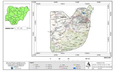
Map Design company in Lagos, Abuja Nigeria
Geoinfotech is a map design company in Lagos, Abuja, Nigeria. With highly skilled cartographers and Map analysts who carefully create maps from the various spheres of inspired maps across Nigeria. What is a Map Design: An aggregate of all the thought processes that...
CONTACT US