404
Oops!, that page can’t be found.
There are other options that might interest you below
Oops!, that page can’t be found.
There are other options that might interest you below
Search Results

Map of Nigeria to be made by Partners of OSGOF
Map Of Nigeria To Be made By Partners Of OSGOF Its been revealed that The Office of the Surveyor-General of the Federation (OSGoF) in Nigeria has planned to produce a large-scale base map of the entire country in partnership with Woolpert, a multinational company, and...

Geoinfotech Concludes Training for Latest Batch of Students
Geoinfotech Concludes Training for Latest Batch of Students The Geoinfotech team of service providers has just concluded the 22 nd edition of its Geographic Information Systems (GIS) beginners training class. The 3-week-long intensive class which began on the 27th of...

Differences Between Maps And Photographs
What is a Map? Maps are graphic representations of selected Earth features. It is a symbolic depiction emphasizing relationships between elements of some space, such as objects, regions, or themes. Many maps are static, fixed to paper, or some other durable medium,...

Remote Sensing and GIS Application in Water Pollution
Remote Sensing and GIS Application in Water Pollution Remote Sensing and GIS Application in Water is valuable in managing water resources, to eliminating pollution on groundwater, and surface water. GROUNDWATER Groundwater is the largest available source of fresh...

How we apply GPS in land surveying
For the rest of this blog post, I will tell you how we apply GPS in land surveying and its various applications. The term GPS is an accurate global radio-navigation system that utilizes signals from a network of satellites to provide a globe's surface location,...

Here’s why hiring the right web app developer shouldn’t be a thing of panic
Here's why hiring the right web app developer shouldn’t be a thing of panic, at Geoinfotech we provide suitable developers who can meet up with your product development requirements no matter how challenging they may present themselves. First things first we put into...

Fashola admonish surveyors to increase the generation of geospatial data
On Thursday (04/14/2022), Fashola admonish surveyors to increase the generation of geospatial data during the inauguration of the 59-member council drawn from all states of the federation, as this stands to also improve the economic development of the country In his...
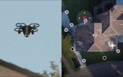
All you need to know about Home Security Drones
All you need to know about Home Security Drones is another major breakthrough in controlling home theft issues and other intrusions. And over the years, the manufacturers have made new leaps towards improving home security and surveillance. Today we delve into all you...

AutoCAD’s relevance to GIS users
With so many rapid changes in technology, AutoCAD's relevance to GIS users cannot be over-emphasized. For this reason, most people use the GIS mechanism and so there is a need to create interfaces between CAD and GIS. And with several essential modifications to...
CONTACT US