404
Oops!, that page can’t be found.
There are other options that might interest you below
Oops!, that page can’t be found.
There are other options that might interest you below
Search Results
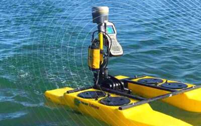
Bathymetry Aerial or Drone Services in Lagos
Bathymetry Aerial or Drone Services in Lagos Bathymetry measures the depth of water in oceans, rivers, or lakes. Bathymetric maps look a lot like topographic maps, which use lines to show the shape and elevation of land features. On topographic maps, the tubes...

Introduction to GIS Manual
Introduction to GIS Manual GIS means Geographic Information System, this system consists of a set of tools that are used for collecting, storing, retrieving, transforming, and displaying spatial data from the real world for a particular set of purposes. This System...
Gis Mapping Remote Sensing and Satellites Services Near Me
Gis Mapping Remote Sensing and Satellites Services Near Me Gis Mapping Remote Sensing and Satellites Services Near Me GIS: A geographic information system is a system that creates, manages, analyzes, and maps all types of data. It connects data to a map, integrating...

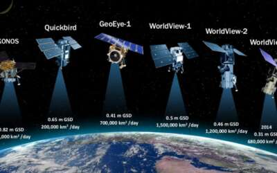
Remote Sensing Satellite and Mapping Services Near Me
Remote Sensing Satellite and Mapping Services Near Me Remote Sensing, Satellite, and Mapping services have become important for businesses and organizations in Nigeria, as they allow for the collection, management, analysis, and visualization of geographic and...

Geographic Information System (Gis) Companies in Abuja
Geographic Information System (Gis) Companies in Abuja Geographic Information Systems (GIS) are becoming increasingly crucial for businesses and organizations in Nigeria, particularly in the cities of Abuja. GIS technology allows for the collection, management,...
Geographic Information System (Gis) Companies in Lagos
Geographic Information System (Gis) Companies in Lagos Geographic Information Systems (GIS) are becoming increasingly crucial for businesses and organizations in Nigeria, particularly in the cities of Lagos. GIS technology allows for the collection, management,...

Topographic Surveying in Abuja
Topographic Surveying in Abuja Topographic Surveying in Abuja Topographic surveying, otherwise called contour surveying or topographical land surveying is basically the first step in any construction or development project. The topographical survey identifies and maps...

Topographic Surveying in Lagos
Topographic Surveying in Lagos Topographic Surveying in Lagos Topographic surveying, otherwise called contour surveying or topographical land surveying is basically the first step in any construction or development project. The topographical survey identifies and maps...

Perimeter Surveying in Abuja
Perimeter Surveying in Abuja Perimeter Surveying in Abuja You may be vaguely acquainted with the term ‘land surveying’, but for people about to partake in real estate transactions or to build a new property, it is a necessary service. Perimeter survey is especially...
CONTACT US