404
Oops!, that page can’t be found.
There are other options that might interest you below
Oops!, that page can’t be found.
There are other options that might interest you below
Search Results

Understanding the Value Encoded in a Single Raster Pixel
When we look at a satellite image, it’s easy to admire the big picture — colorful landscapes, weather patterns, vegetation cover, or even urban development. But behind every vivid map or image lies something deceptively simple: pixels. In raster data, each of these...

GIS DATA SOURCE YOU SHOULD KNOW
Good GIS data is the foundation of any great map. Your work is only as good as the data behind it whether you're mapping for research, urban planning, or app development. In this post, we have gathered the most trusted, free GIS data sources what they offer, how to...

The Integration of GIS and Remote Sensing with Artificial Intelligence: Transforming Spatial Intelligence
In an era defined by data, the fusion of Geographic Information Systems (GIS), remote sensing, and Artificial Intelligence (AI) is revolutionizing how we understand and interact with the world around us. This powerful triad is enabling smarter decisions in urban...
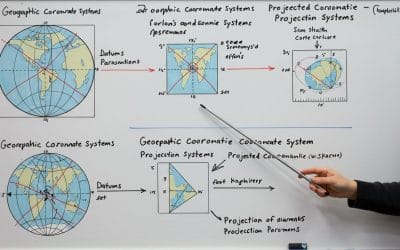
Understanding Coordinate Systems in GIS: A Beginner’s Guide
Have you ever wondered why your map is misplaced on your display pane? Or why you imported a shapefile an its displayed on a different location? That’s because you have probably run into a coordinate system issue. Or imagine you’re a city planner mapping flood-prone...

The Future of GIS Careers: Skills to Learn Now
In a world increasingly driven by data, location is becoming one of the most powerful dimensions of insight, and at the heart of that insight lies Geographic Information Systems (GIS). The GIS field is evolving rapidly, transforming from traditional mapping into a...

THE SURVEYOR OF TOMORROW
Surveyors have a broader array of impactful tasks than ever before: Tackling environmental challenges, ensuring sustainable urban growth, contributing to the reshaping of industries such as construction, and enabling ambitious engineering projects. Traditional...

SOME GEOSPATIAL TECHNOLOGIES UNVEILED AT GEO WEEK 2025
At the highly anticipated annual Geo Week 2025 conference in Denver, Colorado, known for bringing together professionals from various sectors, including surveying, mapping, and remote sensing, a number of industry leaders showcased their company’s latest advancements...

BEST DRONES FOR LAND SURVEYS – TOP MODELS FOR 2025
Top Drones for Surveying in 2025 DJI Matrice 350 RTK: Known for its long flight times and ability to carry heavy payloads, it's ideal for large-scale projects. The DJI Matrice 350 RTK is a powerful workhorse designed for demanding aerial surveying and inspection...
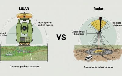
LiDAR vs Radar Survey Instruments
What's the Difference and Which One Wins in the Field? In the fast-evolving world of geospatial technology, surveyors, mappers, and remote sensing professionals have more powerful tools than ever before. Two of the biggest players: LiDAR and Radar. While they might...
CONTACT US