404
Oops!, that page can’t be found.
There are other options that might interest you below
Oops!, that page can’t be found.
There are other options that might interest you below
Search Results

SIGNIFICANT INFORMATION ON CROP MONITORING USING REMOTE SENSING
Integrated Workflow Crop monitoring through remote sensing follows a structured workflow that transforms raw imagery into actionable agricultural intelligence. The process are firmly summarised as follows: Data Acquisition: Multispectral, hyperspectral, SAR, or...

THERMAL IMAGING AND INSPECTION
Introduction Thermal imaging and inspection is a powerful non-contact and non-destructive technique used to visualize and measure the temperature distribution across the surface of an object or environment. It relies on detecting infrared (IR) radiation emitted by all...

Top Geospatial Skills to Learn in 2025: Stay Ahead of the Tech Curve
The geospatial industry is growing rapidly, and professionals with strong spatial skills are now in very high demand. Many organizations in Nigeria and around the world rely on GIS, drone mapping, AutoCAD, GNSS, and spatial data tools to support daily operations. As a...

Fusing Geo-AI and Drones for Smarter Mapping
The rapid evolution of geospatial technology over the last decade has made one thing clear: the future of mapping will be shaped by the fusion of intelligent systems and autonomous sensing. Drones revolutionized how we collect data, but Geo-AI is redefining how we...
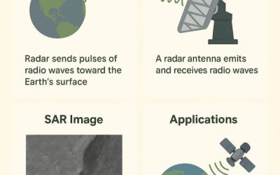
SYNTHETIC APERTURE RADAR (SAR)
1.1 Introduction Synthetic Aperture Radar (SAR) is a type of c by simulating a large antenna (synthetic aperture) using the motion of the radar platform (e.g., aircraft or satellite). This motion allows the radar to collect data from multiple positions and combines...
AutoCAD for Surveyors: Essential Tools for Precision Mapping
Introduction If you’ve ever worked with survey data, you know how important precision is. Every point, every line, every contour tells part of a bigger story. That’s where AutoCAD comes in, the go-to tool for turning survey data into clean, professional maps and...
Applications of Photogrammetry
Photogrammetry is changing the way we collect, analyze, and visualize spatial data. The application of photogrammetry allows surveyors, engineers, and GIS professionals to create accurate 3D models from photographs captured by drones or cameras. Moreover, this...

Mastering GNSS RTK: Best Practices for Training Precision Surveying Professionals
In today’s era of high accuracy positioning, GNSS RTK (Real Time Kinematic) has become a cornerstone technology for precision surveying. From cadastral mapping and engineering design to infrastructure monitoring and geospatial data acquisition, RTK based systems...

Mastering the Skies: Why Every Modern Surveyor Should Learn Drone Pilot Skills.
In today’s fast-changing geospatial world, drones have become essential tools for professionals involved in surveying, mapping, and land management. Knowing how to pilot a drone is no longer just a technical advantage, it’s now a fundamental skill that defines the...
CONTACT US