404
Oops!, that page can’t be found.
There are other options that might interest you below
Oops!, that page can’t be found.
There are other options that might interest you below
Search Results

Revolutionizing Nigerian Infrastructure Security: GEOSTORE’s Real-Time Drone Surveillance System
Operational monitoring of critical infrastructure such as oil pipelines, wellheads, and remote assets, requires timely and continuous visibility. Historically, traditional inspection methods have relied heavily on periodic field visits, which are severely limited by...
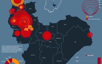
Violence in Jos, Plateau State (2020–2026): Trends, Hotspots, and Fatality Patterns
Introduction Violence in Jos, Plateau State has remained a persistent security challenge, with recurring incidents causing significant loss of life across multiple communities. Rather than isolated events, data from 2020 to 2026 reveals a consistent and structured...

PMS Price Dashboard Nigeria: How GIS is Transforming Fuel Price Monitoring (Geostore)
Tracking PMS Prices in Nigeria: How Geostore’s GIS Dashboard Brings Transparency to the Petroleum Sector Nigeria’s downstream petroleum sector continues to experience significant price variability across states. For consumers, distributors, and regulators, keeping...

Revolutionizing Mineral Prospectivity Mapping in Nigeria Using Google Earth Engine (Geostore Guide)
Revolutionizing Mineral Prospectivity Mapping in Nigeria Using Google Earth Engine | Geostore Nigeria’s mining sector is brimming with untapped potential. However, uncovering these valuable resources has historically been a demanding process. Mineral exploration in...
Mineral Prospectivity Mapping in Nigeria Using Google Earth Engine & Real-Time Geospatial Intelligence
Transforming Nigeria’s Mining Sector: The Power of Geoinfotech’s New Mineral Exploration Web App How can mineral exploration in a resource-rich nation like Nigeria become faster, smarter, and more data-driven? With vast deposits of gold, limestone, and iron ore spread...

Streamline Your Surveying: The New Automated GCP Toolbox Now on GeoStore
In the world of photogrammetry and high-precision surveying, Ground Control Points (GCPs) are the backbone of accuracy. They are the essential anchors that align your spatial data with real-world coordinates, ensuring your orthophotos and digital elevation models are...

GeoStore: GIS Tools For Nigeria
1. The QGIS Topographical Plugin: One-Click Terrain Mastery Running multiple tools for a single terrain analysis is a vibe nobody has time for anymore. This QGIS plugin is a powerhouse designed to simplify complex workflows into a streamlined pipeline: Clip →...

Mastering Terrain Intelligence: How Geoinfotech’s QGIS Topographical Plugin is Redefining Engineering and Planning
In the modern landscape of civil engineering, urban planning and environmental management, the accuracy of spatial data analysis is the foundation upon which every successful project is built. Traditionally, generating comprehensive terrain insights was a fragmented...

Why Accurate Ground Control Points Matter for Your Project And How We’re Making Them Faster
When you commission a drone mapping survey, a cadastral boundary assessment, or an engineering site survey, the quality of the final output depends on something most clients never see Ground Control Points (GCPs). These are the reference markers that anchor your...
CONTACT US