404
Oops!, that page can’t be found.
There are other options that might interest you below
Oops!, that page can’t be found.
There are other options that might interest you below
Search Results

GIS Training Certificate in Nigeria
GIS Training Certificate in Nigeria Enter the growing GIS sector by developing your skills in spatial data analysis, making maps and apps, apply advanced analysis tools. While learning about simple spatial data processing or timely developments such as Programming in...
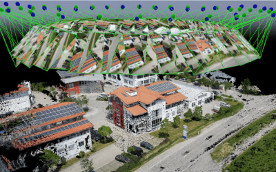
No 1 Drone Companies in Nigeria
Drone companies in Nigeria Drone companies in Nigeria Contact us Geoinfotech is a leading provider of unmanned aircraft (UAV) geographical data collection, high-end aerial photography. We integrate extensive geodesy, topography surveillance, aerial mapping, gas...

How to download Satellite images (Landsat, Sentinel and DEM)
How to download Satellite images How to download Satellite image from usgs 2. Download Satellite Images and DEM for Free 3. HOW TO DOWNLOAD SENTINEL DATA FROM ESA 4. How to download Sentinel 1 & Sentinel 2 satellite...

Watershed Analysis
Watershed Analysis Download Steps to Watershed Analysis and Outline Download Training Data (DEM Image)
GPX to Shape file using QGIS
GPX to Shape file using QGIS Download Sample File GPX to Shape file using QGIS

(Video) Excel to shape file on ArcGIS
Excel to shape file on ArcGIS Download Sample File
Training Files (GPX and Excel)
Training Files (GPX and Excel) Download and Extract the GPX file. The video Tutorial, will be uploaded later tomorrow

1st Field Exercise
1st Field Exercise Geoinfotech Geoinfotech

Basics of Synthetic Aperture Radar
Download here
CONTACT US