404
Oops!, that page can’t be found.
There are other options that might interest you below
Oops!, that page can’t be found.
There are other options that might interest you below
Search Results
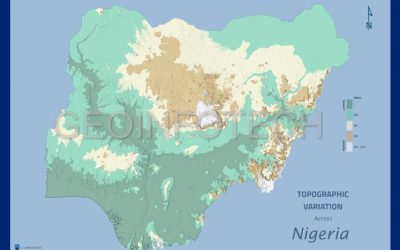
Nigeria Topographic Variation
Topographic variation underpins a myriad of patterns and processes in hydrology, climatology, geography, and ecology and is key to understanding the variation of life on the plane. The topography of the country is mostly flat in the south and some elevated areas and...
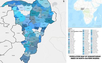
Unveiling the 2023 Humanitarian Needs in North-Eastern Nigeria
In the heart of North-Eastern Nigeria, where the humanitarian situation has remained a focal point of concern, the year 2023 brings with it an urgent need to assess and address the pressing issues. In this blog post, we explore the humanitarian needs in Yobe, Borno,...
How Geoinfotech surveyors work with the principles of GIS
How Geoinfotech surveyors work with the principles of GIS Geoinfotech Surveyors work with the Principles of GIS to help both the government agencies and private organizations, ranging from planning and construction to engineering and land boundary determination. GIS...

Companies that sell Surveying Instruments in NIGERIA?
Companies that sell Surveying Instruments in NIGERIA? Companies that sell Surveying Instruments in NIGERIA? Are you an expert in geospatial data collecting in Nigeria or a land surveyor? If so, having access to trustworthy and excellent surveying equipment is...

Where to get Maps in Nigeria?
WHERE TO GET MAPS IN NIGERIA? In the digital age, maps play a crucial role in our daily lives, assisting us in navigating unfamiliar territories, planning routes, and making informed decisions. If you're in Nigeria and in need of accurate and up-to-date maps, look no...

How to fill training certificate form
How to fill training certificate form Step 1. Goto our website www.geoinfotech.ng Step 2. Go to your course then Click on Curriculum Step 3. After selecting your preferred course, Click on Curriculum Step 4. Scroll down and Click on Show more items...

Measuring Anticipated Effects on the Environment of a Proposed Development Project.
Measuring Anticipated Effects on the Environment of a Proposed Development Project. Fig 1.0: photocredit: Corpbiz Normally, an Environmental Impact Assessment (EIA) is done to quantify the expected environmental effects of a development project. Before a...

Addressing Pest Proliferation Through Geospatial Technology
Addressing Pest Proliferation Through Geospatial Technology Addressing Pest Proliferation Through Geospatial Technology Addressing pest proliferation through Geospatial Technology: Identifying key intervention zones and effectively targeting control measures....

Geoinfotech Visualization of Nigeria’s 2022 Population
Geoinfotech Visualization of Nigeria's 2022 Population Geoinfotech Visualization of Nigeria's 2022 Population We are thrilled to announce that the Geoinfotech team was successful in the projection and visualization of Nigeria’s 2022 population. With our expertise in...
CONTACT US