404
Oops!, that page can’t be found.
There are other options that might interest you below
Oops!, that page can’t be found.
There are other options that might interest you below
Search Results

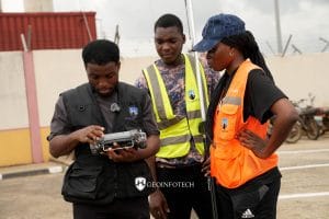
Drone Survey Services in Ondo State
Drone Survey Services in Ondo State At Geoinfotech, we provide professional drone survey services across Ondo State. Our solutions deliver speed, accuracy, and value that traditional survey methods often cannot match. Whether you are a land developer, government...
Drone Survey Services in Ogun State
Drone Survey Services in Ogun State At Geoinfotech, we provide professional drone survey services across Ogun State, including Abeokuta, Ijebu-Ode, Sagamu, Ota, Ilaro, and surrounding communities. Our solutions deliver speed, accuracy, and value that traditional...

Stopping Pipeline Vandalism in Nigeria with Drone Surveillance and AI
Stopping Pipeline Vandalism in Nigeria with Drone Surveillance and AI Nigeria loses billions annually to pipeline vandalism, illegal bunkering, and crude oil theft. For energy companies operating across the Niger Delta and beyond, this is not a statistic, it is a...
Where to Buy ArcGIS Desktop and ArcGIS Pro Manual in Lagos, Nigeria | Step-by-Step GIS Learning Guide
Where to Buy ArcGIS Desktop and ArcGIS Pro Manual, Step-by-Step Guide in Lagos, Nigeria Quick Summary Looking for where to buy ArcGIS Desktop and ArcGIS Pro Manual in Lagos, Nigeria, Abuja, Port Harcourt, Kano, or anywhere near you? This guide explains how to access...

Where to Buy Agisoft Metashape in Lagos, Nigeria | Genuine Photogrammetry Software Licenses
Where to Buy Agisoft Metashape in Lagos, Nigeria Quick Summary Looking for where to buy Agisoft Metashape in Lagos, Nigeria, Abuja, Port Harcourt, Kano, or anywhere across the country? This guide explains what Agisoft Metashape is, its major applications in drone...

Where to Buy ArcGIS Network Analyst Extension in Lagos, Nigeria | Genuine ArcGIS Licensing & Support
Where to Buy ArcGIS Network Analyst Extension in Lagos, Nigeria Quick Summary Looking for where to buy the ArcGIS Network Analyst Extension in Lagos, Nigeria, Abuja, Port Harcourt, Kano, or anywhere across the country? This guide explains what ArcGIS Network Analyst...

Drone Livestreaming in Nigeria
Drone Livestreaming in Nigeria For years, commercial drone operations followed a predictable pattern. A pilot flew a mission, saved data to an SD card, and uploaded it hours later. While valuable, this delayed workflow creates a dangerous data gap during emergencies....
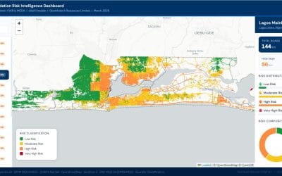
Lagos Road Risk Dashboard: Explore Every LGA
Picture the scene: you want to understand road risk across Lagos. You do not want a static report. You want to explore the data yourself, click on any road, and get the facts instantly. Our Lagos road risk dashboard gives you exactly that. You can access the Lagos...
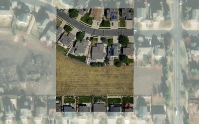
Georeferencing Satellite Imagery: Process, Methods, and GIS Applications
Georeferencing Satellite Imagery Georeferencing is one of the most important processes in GIS and remote sensing. It ensures that satellite imagery aligns correctly with real-world geographic coordinates so that the image can be accurately used...
CONTACT US