404
Oops!, that page can’t be found.
There are other options that might interest you below
Oops!, that page can’t be found.
There are other options that might interest you below
Search Results
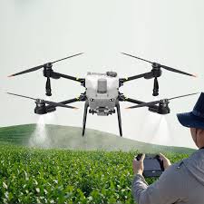
HOW DRONES ARE REVOLUTIONISING CROP MONITORING IN 2026
Have you ever wondered how farmers manage to monitor hundreds of hectares of crops without physically walking through every field? Imagine a farmer standing at the edge of a vast farm, worried about sections of crops turning yellow but unsure of the cause. Instead of...
Route to Profit: Using GIS & GPS for Logistics Optimization in Nigeria (2026)
Efficient transportation is the heartbeat of the modern Nigerian economy. However, logistics operators face a unique "trinity of trouble": traffic congestion in Lagos, high fuel costs, and vehicle security risks. In 2026, Geographic Information Systems (GIS)...
Eye of the Storm: Why Drones are the New Standard for Roof Inspections in Nigeria (2026)
Storm events—heavy rainfall, strong winds, and tropical cyclones—are the primary enemies of building longevity. As the first line of defense, your roof is often the first to fail, leading to water ingress, structural rot, and massive financial loss. In 2026,...

Case Study: Successful Land Survey Project in Abuja Using Drone + GPS Tools (2026)
Abuja, Nigeria’s capital, is currently undergoing a massive geospatial transformation. With the Federal Government launching "Digital Twin" initiatives to map the city in 3D, the demand for high-precision surveying has never been higher. In this case study, we pull...

How to Choose the Right GIS & Surveying Software Licenses in Nigeria (2026 Guide)
For small surveying firms in Lagos, Abuja, and beyond, buying the wrong software license isn't just a mistake—it’s a multi-million Naira setback. As global giants move purely to subscription-based models (SaaS), your firm needs a licensing strategy that balances...
DJI Drone Mapping for Agricultural Land Surveys in Nigeria: Benefits & Equipment (2026 Guide)
In 2026, the name DJI is synonymous with the "Green Revolution" in Nigeria. From the massive rice clusters in Kebbi to the palm plantations of Edo and the fruit orchards in Oyo, DJI’s ecosystem provides the only end-to-end solution for mapping, crop analysis, and...

Why GIS & Remote Sensing Tools Are Essential for Land-Use Planning in Nigeria (2026 Guide)
As Nigeria’s population continues its rapid ascent—projected to surpass 235 million in 2026—the pressure on our land resources has reached a boiling point. From the urban sprawl of Lagos and Kano to the agricultural heartlands of the Middle Belt, the "old way" of...

Drone Regulations and Safety Tips for Surveying Projects in Nigeria (2026 Guide)
The landscape of Nigerian surveying has shifted. High-precision mapping is no longer just a ground-based job; it happens in the sky. However, with the rise of Unmanned Aerial Vehicles (UAVs) comes a strict regulatory environment managed by the Nigerian Civil Aviation...

How to Get Accurate Topographic Maps for Lagos Urban Planning (2026 Professional Guide)
Whether you are an urban planner, a civil engineer, or a real estate developer, navigating the complex terrain of Lagos requires more than just a satellite view. In 2026, the stakes for accurate data have never been higher. With rapid urbanization in areas like...
CONTACT US