Document

GIS ANALYSIS IN NIGERIA

 What is GIS analysis? GIS (Geographic Information System) analysis is a powerful tool that helps us understand and interpret spatial data. It’s like having a superpower that allows us to visualize and analyze complex relationships between different factors in our environment.

In Nigeria, GIS analysis has numerous applications across various industries. For instance, in environmental management, GIS helps us track land use changes, monitor water quality, and identify areas prone to natural disasters. In urban planning, GIS enables us to design efficient transportation systems, optimize land use, and develop sustainable cities.

GIS

How to perform GIS analysis?

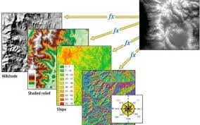
To perform GIS analysis, various techniques like spatial analysis, geostatistical analysis, network analysis, and 3D analysis are applied.

  • Spatial analysis: helps us understand spatial relationships and patterns. E.g. spatial autocorrelation, spatial interpolation.
  • Geostatistical analysis: allows us to analyze spatial data using statistical methods. E.g., kriging, variography.
  • Network analysis: studies connectivity and routes, and 3D analysis enables us to visualize and analyze terrain and 3D data. E.g., route optimization, network modeling).

GIS

GIS analysis Software and Technologies Used in Nigeria.

To perform these analyses, we use specialized software like ArcGIS, QGIS, and Google Earth Engine. These tools provide us with the capabilities to manipulate, analyze, and visualize spatial data. We also use programming languages like Python, R, and SQL

Data Collection and Processing in Nigeria.

  • Data sources: Satellite imagery (e.g., Landsat, Sentinel-2), surveys (e.g., field data collection), GPS data (e.g., location tracking).
  • Data formatting and cleaning: Preprocessing (e.g., data conversion), data integration (e.g., merging datasets).
  • Data visualization and mapping: Cartography (e.g., map design), visualization tools (e.g., charts, graphs).

Challenges and Solutions in GIS Analysis.

One of the major challenges is ensuring data quality and availability. We need accurate and reliable data to produce meaningful results. Another challenge is Scaling and resolution:  which can affect the accuracy of our analysis. Finally, integrating GIS with other technologies like remote sensing and machine learning can be challenging, but also incredibly powerful.

 GEOINFOTECH RESOURCES LIMITED

At GEOINFOTECH RESOURCES LIMITED, we offer series of services, trainings and certifications in GIS. We help organizations and individuals leverage the power of GIS analysis to make informed decisions, optimize resources, and drive innovation.

  1. Expertise: GIS, Surveying, Mapping, Spatial data analysis
  2. Services; Data collection,Data processing, DATA ANALYSIS, Data mapping and visualization;, Training and support.

 How to Get Started with GIS in Geoinfotech:

  • Training programs and workshops: Our training program is designed to help you succeed in this exciting and rapidly evolving field. Some of the courses offered are training programs, workshops, and online courses
  •  Certifications: professional certifications in GIS and surveying
  •  Professional development opportunities: workshops, conferences, and projects

GEoinfotech

Benefits of partaking in our program:

  • Practical Skills: Get hands-on experience with drone technology and learn how to use it for aerial surveying and mapping.
  • Certification: Receive a recognized certification that will make you stand out from the crowd and show potential clients that you’re a pro.
  • Industry Knowledge: Stay up-to-date with the latest industry trends and best practices, and learn how to apply them in real-world scenarios.
  • Career Opportunities: Enhance your career prospects in fields like surveying, mapping, GIS, and remote sensing.
  • Networking: Connect with other professionals and potential clients in the industry, and build valuable relationships that can help you grow your business.
  • Business Opportunities: Learn how to offer aerial surveying and mapping services to clients, and potentially start your own business.

 Together, let’s unlock the potential of GIS analysis in Nigeria.

Sign up today at https://geoinfotech.ng/training/ and take your career or business to new heights!

For more info:  Contact us at https://geoinfotech.ng/contact-geoinfotech-technology-contact-us/


Our Portfolio

Check out our previous projects on GIS, Drone, Land Surveyor and Mapping Services in Nigeria

Advanced Drone-Based Topographic Survey for Precision Land Development Planning

Advanced Drone-Based Topographic Survey for Precision Land Development Planning

Mapping the Future: Comprehensive Area Survey Transforms Land Development in Akure

Mapping the Future: Comprehensive Area Survey Transforms Land Development in Akure

Precision Topographical Survey and Mapping for Smarter Infrastructure Planning

Precision Topographical Survey and Mapping for Smarter Infrastructure Planning

Precision Drone Volumetric Surveys: How Purechem Industries Optimized Mineral Stockpile Management

Precision Drone Volumetric Surveys: How Purechem Industries Optimized Mineral Stockpile Management

Advanced Mapping & Environmental Survey for Ilubirin Property, Lagos Island

Advanced Mapping & Environmental Survey for Ilubirin Property, Lagos Island

Unveiling the Invisible: LiDAR Technology Transforms Terrain Analysis in Abeokuta North

Unveiling the Invisible: LiDAR Technology Transforms Terrain Analysis in Abeokuta North

LAND USE/LAND COVER MAPPING AND ANALYSIS OF AKURE, NIGERIA

LAND USE/LAND COVER MAPPING AND ANALYSIS OF AKURE, NIGERIA

 DETAILED AERIAL, LAND SURVEY AND GIS ANALYSIS FOR ADVANCED REAL ESTATE DEVELOPMENT

 DETAILED AERIAL, LAND SURVEY AND GIS ANALYSIS FOR ADVANCED REAL ESTATE DEVELOPMENT

Professional Drone Mapping and GIS Training For ETA-ZUMA Mining Company

Professional Drone Mapping and GIS Training For ETA-ZUMA Mining Company

Installation of Intelligent Traffic Lights

Installation of Intelligent Traffic Lights

Geological Report on a Mining/Exploration Survey

Geological Report on a Mining/Exploration Survey

Drone Survey and Mapping of Shaishen Foods Limited

Drone Survey and Mapping of Shaishen Foods Limited

Gold Site Suitability Analysis in North Africa

Gold Site Suitability Analysis in North Africa

Lidar Topographic Mapping Project

Lidar Topographic Mapping Project

Geophysical/hydrogeophysical Studies for Groundwater Development

Geophysical/hydrogeophysical Studies for Groundwater Development

Togo Digital Terrain Model Project

Togo Digital Terrain Model Project

Drone Mapping of Parts of Lome Rail Line for Graceland Energy Located at Lome Togo

Drone Mapping of Parts of Lome Rail Line for Graceland Energy Located at Lome Togo

Drone/land Survey of Pure-chem Industrial Limited, Ogun State.

Drone/land Survey of Pure-chem Industrial Limited, Ogun State.

Drone Inspection/survey of Southern Lake Estate, Chevron, Lekki, Lagos State

Drone Inspection/survey of Southern Lake Estate, Chevron, Lekki, Lagos State

Anniversary-Workshop on the Application of Remote Sensing and Drone Technology in GIS -Abuja

Anniversary-Workshop on the Application of Remote Sensing and Drone Technology in GIS -Abuja

Topographic Mapping of Oyo State

Topographic Mapping of Oyo State

Topographic Mapping of Part of the Local Government Areas in Oyo State

Topographic Mapping of Part of the Local Government Areas in Oyo State

Topographic Mapping of Part of Kwara, Ekiti and Kogi State Local Government Area

Topographic Mapping of Part of Kwara, Ekiti and Kogi State Local Government Area

Political Map of South West, Nigeria Located in Nigeria

Political Map of South West, Nigeria Located in Nigeria

Topographic Mapping of Parts of Niger State Located at Niger State, Nigeria

Topographic Mapping of Parts of Niger State Located at Niger State, Nigeria

Topographic Mapping of Part of Kwara, Ekiti, and Kogi State Local Government Area Located in Nigeria

Topographic Mapping of Part of Kwara, Ekiti, and Kogi State Local Government Area Located in Nigeria

Topographic Mapping of Part of Kwara State Local Government Area Located at Kwara State Nigeria

Topographic Mapping of Part of Kwara State Local Government Area Located at Kwara State Nigeria

Guide Map of Oshodi Transport Interchange Located in Lagos

Guide Map of Oshodi Transport Interchange Located in Lagos

Flood Analysis of Amuwo-odofin Orthophoto.

Flood Analysis of Amuwo-odofin Orthophoto.

Site Inspection Using Drone of Water Corporation Located at Oke-aro Agege

Site Inspection Using Drone of Water Corporation Located at Oke-aro Agege

24,000 meter Lome Rail Line for Drone Mapping, Graceland Energy Located at Lome, Togo

24,000 meter Lome Rail Line for Drone Mapping, Graceland Energy Located at Lome, Togo

10 Drone Inspection Traffic Signal in Lagos

10 Drone Inspection Traffic Signal in Lagos

Lagos October 1st Free GIS Training Workshop

Lagos October 1st Free GIS Training Workshop

Abuja GIS Training 12th of August 2022

Abuja GIS Training 12th of August 2022

Osun state parcel project

Osun state parcel project

Drone Mapping & Vectorization Of Abu-allied Farm

Drone Mapping & Vectorization Of Abu-allied Farm

Proposal for aerial deployment, tracking and monitoring of threats in victoria island phase 1 and ikoyi phase 2, nigeria

Proposal for aerial deployment, tracking and monitoring of threats in victoria island phase 1 and ikoyi phase 2, nigeria

Jabi Lake Mall Solar Inspection – Abuja

Jabi Lake Mall Solar Inspection – Abuja

Ground Control and Drone Survey for Mast 3D Modeling

Ground Control and Drone Survey for Mast 3D Modeling

Telecom Drone 3D and 2D Modeling of Cellsite

Telecom Drone 3D and 2D Modeling of Cellsite

Free GIS Spatial Analysis Training (Lagos Branch)

Free GIS Spatial Analysis Training (Lagos Branch)

800 Building Plots Aerial Capture and Delineation for Database. Greenfield Estate

800 Building Plots Aerial Capture and Delineation for Database. Greenfield Estate

100 Hectares Aerial Survey with Differential GPS of High Accuracy

100 Hectares Aerial Survey with Differential GPS of High Accuracy

Protected: Nigeria Crime Report and Dashboard

Protected: Nigeria Crime Report and Dashboard

Drone Survey and Mapping – Victoria Island  Copy

Drone Survey and Mapping – Victoria Island Copy

Akwa-Ibom 500 Hectares Drone Survey and Mapping in Nigeria

Akwa-Ibom 500 Hectares Drone Survey and Mapping in Nigeria

Ground Control Establishment – Republic of the Niger – Kano, Kastina, Jigawa, Kaduna

Ground Control Establishment – Republic of the Niger – Kano, Kastina, Jigawa, Kaduna

Drone Survey and Mapping – Victoria Island

Drone Survey and Mapping – Victoria Island

Control Point Establishment – DGPS

Control Point Establishment – DGPS

Land Survey – Northern Nigeria

Land Survey – Northern Nigeria

Biodiversity Mapping – Sweden

Biodiversity Mapping – Sweden

Flood Impact Mapping – United Kingdom

Flood Impact Mapping – United Kingdom

M and E GIS Dashboard for Control Establishment Project

M and E GIS Dashboard for Control Establishment Project

Geodatabase Management System Training For National Boundary Commission

Geodatabase Management System Training For National Boundary Commission

Nigeria Topographic Map – Project

Nigeria Topographic Map – Project

Abuja Training on Introduction to GIS

Abuja Training on Introduction to GIS

200 Hectares Land and Drone Survey – Lagos Nigeria

200 Hectares Land and Drone Survey – Lagos Nigeria

Inspection of 30 hectares drainage

Inspection of 30 hectares drainage

Drainage Drone Mapping and Surveying in Lagos Nigeria

Drainage Drone Mapping and Surveying in Lagos Nigeria

GIS Cadastral Mobile Application

GIS Cadastral Mobile Application

Abuja Topographical Map – HD GIS Mapping

Abuja Topographical Map – HD GIS Mapping

Ground Topography Survey (Lagos Island)

Ground Topography Survey (Lagos Island)

2.7km2 Topography Survey in Snake Island

2.7km2 Topography Survey in Snake Island

GIS Masterclass

GIS Masterclass

Sokoto Contour Map

Sokoto Contour Map

NDVI Vegetation Assessment in Lagos State

NDVI Vegetation Assessment in Lagos State

Lagos drone training master class

Lagos drone training master class

Ifako drone topographic survey and mapping

Ifako drone topographic survey and mapping

CMD Lagos 3D mapping aerial modeling

CMD Lagos 3D mapping aerial modeling

GIS and Drone Masterclass

GIS and Drone Masterclass

Drone aerial survey and mapping – Lagos Island _ Somolu

Drone aerial survey and mapping – Lagos Island _ Somolu

Drone Pilot Mapping and Aerial Photography

Drone Pilot Mapping and Aerial Photography

AutoCAD Mapping and Surveying

AutoCAD Mapping and Surveying

Mapping with GIS for Maritime Boundary

Mapping with GIS for Maritime Boundary

GIS for Maritime using ArcGIS and QGIS

GIS for Maritime using ArcGIS and QGIS

Migrating from ArcMap to ArcGIS Pro

Migrating from ArcMap to ArcGIS Pro

Getting started with Web Mapping using ArcGIS

Getting started with Web Mapping using ArcGIS

Geographic Information System – Python, SQL, DBMS

Geographic Information System – Python, SQL, DBMS

Introduction to GIS [NYSC Special]

Introduction to GIS [NYSC Special]

Drone Photography and Videography

Drone Photography and Videography

Introduction to GIS

Introduction to GIS

Drone Training for Beginners

Drone Training for Beginners

Covid-19 | Nigeria Data Visualisation

Covid-19 | Nigeria Data Visualisation

Benue Flood Analysis

Benue Flood Analysis

Aerial photography Ile-Ife Osun State

Aerial photography Ile-Ife Osun State

Kenya Forest Project

Kenya Forest Project

Tunsun Consultants Ltd

Tunsun Consultants Ltd

Introduction To Gis In Maritime at the National Boundary Commission

Introduction To Gis In Maritime at the National Boundary Commission

Training on GIS and Drone Mapping (batch-4 & 5)

Training on GIS and Drone Mapping (batch-4 & 5)

Osun Flood Mapping

Osun Flood Mapping

Lahass International Limited

Lahass International Limited

Linguistic Association of Nigeria

Linguistic Association of Nigeria

West African Indexing Services

West African Indexing Services

Lagos Ikeja Road Network Map

Lagos Ikeja Road Network Map

LASU Land Regularisation Portal

LASU Land Regularisation Portal

Lingua Plus International

Lingua Plus International

Lagferry Web Route

Lagferry Web Route

COURSES

Explore Geoinfotech courses and establish a strong foundation of knowledge and skills to be productive with the latest Technology.

Drone Pilot for Beginners

The Drone Beginners Training course is a comprehensive program designed to equip participants with the necessary skills and knowledge to operate drones effectively and safely in a professional setting.
Duration: 3 Weekends (Every Friday 2pm and Saturday 10am)
Package: Field Experience, 100% Hands-on practical, jotter, Biro and Software Others, Test, Exam and Certificate.

Find out more
Training Venue Available in,Lagos and Abuja100253Nigeria
+ Google Map

[Beginners to Advanced Class] Geographic Information System (ArcGIS Desktop and ArcGIS Pro)

This course will develop your skills in spatial data analysis, making maps application of Python, apply SQL as a standard language for accessing and manipulating databases.
Duration: 3 Weekends (Every Friday 2pm and Saturday 10am)
Package: Field Experience, 100% Hands-on practical, jotter, Biro and Software Others, Test, Exam and Certificate.

Find out more

Drone Pilot for Beginners to Professional

The Drone Professional Training course is a comprehensive program designed to equip participants with the necessary skills and knowledge to operate drones effectively and safely in a professional setting.
Duration: 3 Weekends (Every Friday 2pm and Saturday 10am)
Package: Field Experience, 100% Hands-on practical, jotter, Biro and Software Others, Test, Exam and Certificate.

Find out more
Training Venue Available in,Lagos and Abuja100253Nigeria
+ Google Map

Differential GPS (DGPS) Land Surveying Training

Professional 2 weekends ▪ Field Experience 5.0 (100% Practical) ▪ Exam & CertificateFree Software and AppsHands on Practical and Field…

Find out more

YOU MAY ALSO LIKE...