Document

Agroecology Zones in Nigeria

We work with precision and accuracy

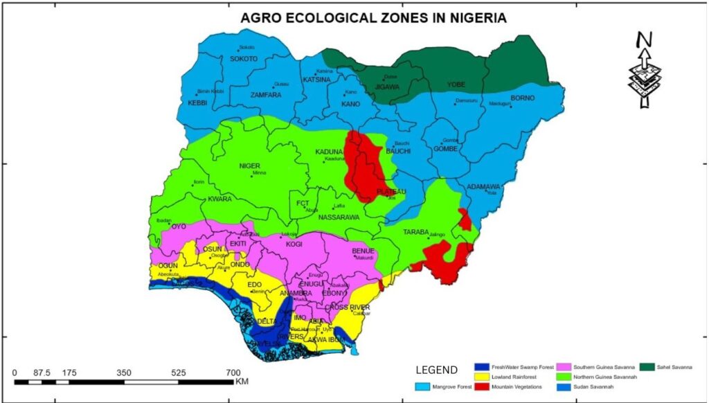
Nigeria is a country recognized for its great cultural diversity and abundant natural resources. One of its most valuable advantages, often overlooked, is its agroecological diversity. is the application of ecological concepts and principles in farming. the agroecological zone promotes farming practices that put farmers and communities in the driving seat.

CLEARLY;

They give power to approaches led by local people and adapt agricultural techniques to suit the local area and its specific social, environmental, and economic conditions.Nigeria’s geography is separated into numerous agroecological zones, each with its own set of climatic, soil, and topographical characteristics that have a significant impact on the country’s agricultural potential.

Nigeria’s agroecological zones can be categorized into;

  • Mangrove Fores
  • Freshwater swamp Forest
  • Sudan savanna
  • Northern Guinea savanna
  • Mountain vegetation
  • Southern Guinea savanna
  • Lowland Rainf
  • Sahel savanna

Agro-Ecological Zone in Nigeria 

agroecological zone

  • Abia; Southern Guinea Savanna, Lowland Rainforest
  • Abuja: Northern Guinea Savanna
  • Adamawa; Northern Guinea Savanna, Montane
  • Akwa Ibom; Lowland Rainforest
  • Anambra; Southern Guinea Savanna, Freshwater Swamp
  • Bauchi; Northern Guinea Savanna, Sudan Savanna, Montane
  • Bayelsa; Mangrove Swamp, Freshwater Swamp
  • Benue; Northern Guinea Savanna, Southern Guinea Savanna, Lowland Rainforest
  • Borno; Sudan Savanna, Sahel Savanna
  • Cross River; Southern Guinea Savanna, Freshwater swamp, Lowland Rainforest
  • Delta; Mangrove swamp, Freshwater Swamp, Lowland Rainforest
  • Ebonyi: Southern Guinea Savanna
  • Edo; Southern Guinea Savanna, Freshwater Swamp, Lowland Rainforest
  • Ekiti; Southern Guinea Savanna
  • Enugu; Southern Guinea Savanna
  • Gombe; Sudan Savanna
  • Imo; Southern Guinea Savanna, Freshwater Swamp, Lowland Rainforest
  • Jigawa; Sahel Savanna
  • Kaduna; Northern Guinea Savanna, Sudan Savanna, Montane
  • Kano; Northern Guinea Savanna, Sudan Savanna, Montane
  • Katsina; Sudan Savanna, Sahel Savanna
  • Kebbi; Sudan Savanna
  • Kogi; Northern Guinea Savanna, Southern Guinea Savanna
  • Kwara; Northern Guinea Savanna
  • Lagos; Freshwater Swamp
  • Nasarawa; Northern Guinea Savanna, Montane
  • Niger; Northern Guinea Savanna
  • Ogun; Southern Guinea Savanna, Freshwater Swamp, Lowland Rainforest
  • Osun; Southern Guinea Savanna, Lowland Rainforest
  • Oyo; Northern Guinea, Savanna, Southern Guinea Savanna, Lowland Rainforest
  • Plateau; Montane, Sudan Savanna, Northern Guinea, Savanna
  • Rivers: Freshwater Swamp, Lowland Rainforest
  • Sokoto; Sudan Savanna
  • Taraba; Northern Guinea Savanna, Montane
  • Yobe; Sahel Savanna
  • Zamfara; Sudan Savanna

Envisioning:

  • The Guinea savanna (or savanna woodland/wooded savanna) is the most extensive vegetation in the Middle belt of Nigeria and consists of a mixture of trees and grass. Characteristic of this zone is the woodland savanna, which consists of an open stand of trees, the crowns of which form a canopy from 8 – 20 m or more in height and cover at least 40% of the surface. Tree species include; Shea butter, Oil palm, Isoberlina spp., Danielliaoliveri, Lophiraalata, and
    Terminalia spp.It has two types; Northern and Southern.
  • The Sudan savanna belt is found in the Northern parts of Nigeria and stretches from the Sokoto Plain through the Northern section of the High Plains of Nigeria to the Chad Basin. The Sudan savanna is characterized by high rainfall variability and frequent, together with poor soil fertility being a major constraint to agriculture in the region. The zone has the largest population density in Northern Nigeria, produces important economic crops such as groundnuts, cotton, millet, and maize, and has the highest concentration of cattle in the country.
  • The Sahel savanna is found in the extreme Northwest and Northeast of the country. It is a transitional eco-region of semi-arid grasslands, savannahs, steppes, and thorn shrubs lying between the woodedsavanna to the south, and the Sahara to the north.
  • The Mangrove Swamps; along the coastal areas of the Niger Delta region, Nigeria’s Mangrove Swamps are characterized by brackish water and marshy lands. Fishing and aquaculture are the primary economic activities in this zone due to the proximity to water bodies. The fertile soil is also suitable for cultivating oil palm and rice. Sustainable management and protection of these wetlands are crucial to maintaining the ecological balance while ensuring a steady supply of fish and other aquatic resources
  • Lowland Rainforest Zone; the Rainforest Zone, covering the southern part of Nigeria, including states like Cross River and Ogun, experiences high rainfall throughout the year. This region is lush and fertile, ideal for a wide range of crops, such as cocoa, oil palm, rubber, and various fruits and vegetables. It is also known for its biodiversity and potential for agroforestry initiatives.
  • Freshwater swamp; Wetland environments include freshwater swamp forests. During the dry season, the terrain is quite uneven, with numerous spots of open water. During the wet season, they are frequently inundated. They form a fringe of coastal vegetation after the mangroves in Nigeria’s Niger Delta region.
  • Montane is an ecosystem found in mountains. It is influenced by colder weather at moderate elevations. In these places, dense forests are common. Rainfall and a temperate climate cause natural vegetation to vary in Mountain Forest.
Mangrove swampsBayelsa, Delta, and River states
Northern guinea savannaNiger, Taraba, Kaduna, Bauchi, Kano, Adamawa, Benue, Kwara, Kogi, Oyo, Abuja, Nasarrawa, Benue, Jos, Plateau states
Southern guinea savannaOgun, Kogi, Edo, Anambra, Cross River, Imo, Abia, Benue, Enugu, Ebonyi, Oyo, Ekiti, Osun, states
Sudan savannaSokoto, Kebbi, Zamfara, Katsina, Bauchi, Gombe, Kaduna, Kano, Borno, Plateau States
Sahel savannaYobe, Jigawa and Borno states
Freshwater swampsLagos, Ondo, Edo, Delta, Anambra, Bayelsa, Imo, Rivers, Cross river, Ogun states
Lowland RainforestOgun, Oyo, Osun, Ondo, Edo, Delta, Imo, Rivers, Abia, AkwaIbom, Cross River, Benue
MontaneJos, Kano, Kaduna, Bauchi, Nasarrawa, Taraba, Adamawa, Plateau states

 Why various zones?

Variations in agroecological regions are a result of some phenomena. These phenomena include geology, landforms, soils, vegetation, climate, land use, wildlife, and hydrology. Regardless of the hierarchical level, the relative importance of each trait differs from one zone to the next. The nation’s very diverse agro-ecological zones make it an ideal producing area for a wide range of crops. From smallholder and substantial farmers to large-scale and mechanized farmers, they raise a variety of food crops, the economic, social, and nutritional relevance of which varies by agroecological zone.

Challenges:

  • Climate Variability: In some areas, erratic rainfall patterns can lead to crop failures and food poverty.
  • Soil Erosion: The Forest Zone is especially vulnerable to soil erosion caused by deforestation and poor land management.
  • Improved transportation and storage facilities are critical for connecting farmers to markets and reducing post-harvest losses.
  • Climate Change Resilience: In order to adapt to shifting weather patterns, Nigeria needs to invest in climate-resilient farming systems.
  • Promoting sustainable agriculture, organic farming, and agroforestry can improve soil health and safeguard the environment.

Opportunities:

  • Crop Diversification: Different zones provide opportunities for crop diversification and improved food security.
  • Processing and value addition to agricultural products can increase income and offer job opportunities.
  • Climate-Smart Agriculture: Putting climate-resilient techniques in place can help minimize the effects of climate change

Conclusion:

Nigeria’s agricultural economy is built around agroecological zones. Each zone has a distinct combination of climate, soil, and geography, which influences the types of crops and farming practices appropriate for the region. With the aid of this visual, learning and planning are made easier.

CLICK HERE FOR MORE INFORMATION

Our Portfolio

Check out our previous projects on GIS, Drone, Land Surveyor and Mapping Services in Nigeria

Top 5 most violent states in Nigeria and their emergency centers

LAND USE/LAND COVER MAPPING AND ANALYSIS OF AKURE, NIGERIA

LAND USE/LAND COVER MAPPING AND ANALYSIS OF AKURE, NIGERIA

3D Diorama of the straits of Mackinac

 DETAILED AERIAL, LAND SURVEY AND GIS ANALYSIS FOR ADVANCED REAL ESTATE DEVELOPMENT

 DETAILED AERIAL, LAND SURVEY AND GIS ANALYSIS FOR ADVANCED REAL ESTATE DEVELOPMENT

Professional Drone Mapping and GIS Training For ETA-ZUMA Mining Company

Professional Drone Mapping and GIS Training For ETA-ZUMA Mining Company

Installation of Intelligent Traffic Lights

Installation of Intelligent Traffic Lights

Geological Report on a Mining/Exploration Survey

Geological Report on a Mining/Exploration Survey

Drone Survey and Mapping of Shaishen Foods Limited

Drone Survey and Mapping of Shaishen Foods Limited

Gold Site Suitability Analysis in North Africa

Gold Site Suitability Analysis in North Africa

Lidar Topographic Mapping Project

Lidar Topographic Mapping Project

Geophysical/hydrogeophysical Studies for Groundwater Development

Geophysical/hydrogeophysical Studies for Groundwater Development

Togo Digital Terrain Model Project

Togo Digital Terrain Model Project

Drone Mapping of Parts of Lome Rail Line for Graceland Energy Located at Lome Togo

Drone Mapping of Parts of Lome Rail Line for Graceland Energy Located at Lome Togo

Drone/land Survey of Pure-chem Industrial Limited, Ogun State.

Drone/land Survey of Pure-chem Industrial Limited, Ogun State.

Drone Inspection/survey of Southern Lake Estate, Chevron, Lekki, Lagos State

Drone Inspection/survey of Southern Lake Estate, Chevron, Lekki, Lagos State

Anniversary-Workshop on the Application of Remote Sensing and Drone Technology in GIS -Abuja

Anniversary-Workshop on the Application of Remote Sensing and Drone Technology in GIS -Abuja

Topographic Mapping of Oyo State

Topographic Mapping of Oyo State

Topographic Mapping of Part of the Local Government Areas in Oyo State

Topographic Mapping of Part of the Local Government Areas in Oyo State

Topographic Mapping of Part of Kwara, Ekiti and Kogi State Local Government Area

Topographic Mapping of Part of Kwara, Ekiti and Kogi State Local Government Area

Political Map of South West, Nigeria Located in Nigeria

Political Map of South West, Nigeria Located in Nigeria

Topographic Mapping of Parts of Niger State Located at Niger State, Nigeria

Topographic Mapping of Parts of Niger State Located at Niger State, Nigeria

Topographic Mapping of Part of Kwara, Ekiti, and Kogi State Local Government Area Located in Nigeria

Topographic Mapping of Part of Kwara, Ekiti, and Kogi State Local Government Area Located in Nigeria

Topographic Mapping of Part of Kwara State Local Government Area Located at Kwara State Nigeria

Topographic Mapping of Part of Kwara State Local Government Area Located at Kwara State Nigeria

Guide Map of Oshodi Transport Interchange Located in Lagos

Guide Map of Oshodi Transport Interchange Located in Lagos

Flood Analysis of Amuwo-odofin Orthophoto.

Flood Analysis of Amuwo-odofin Orthophoto.

Site Inspection Using Drone of Water Corporation Located at Oke-aro Agege

Site Inspection Using Drone of Water Corporation Located at Oke-aro Agege

24,000 meter Lome Rail Line for Drone Mapping, Graceland Energy Located at Lome, Togo

24,000 meter Lome Rail Line for Drone Mapping, Graceland Energy Located at Lome, Togo

10 Drone Inspection Traffic Signal in Lagos

10 Drone Inspection Traffic Signal in Lagos

Lagos October 1st Free GIS Training Workshop

Lagos October 1st Free GIS Training Workshop

Abuja GIS Training 12th of August 2022

Abuja GIS Training 12th of August 2022

Osun state parcel project

Osun state parcel project

Drone Mapping & Vectorization Of Abu-allied Farm

Drone Mapping & Vectorization Of Abu-allied Farm

Proposal for aerial deployment, tracking and monitoring of threats in victoria island phase 1 and ikoyi phase 2, nigeria

Proposal for aerial deployment, tracking and monitoring of threats in victoria island phase 1 and ikoyi phase 2, nigeria

Jabi Lake Mall Solar Inspection – Abuja

Jabi Lake Mall Solar Inspection – Abuja

Ground Control and Drone Survey for Mast 3D Modeling

Ground Control and Drone Survey for Mast 3D Modeling

Telecom Drone 3D and 2D Modeling of Cellsite

Telecom Drone 3D and 2D Modeling of Cellsite

Free GIS Spatial Analysis Training (Lagos Branch)

Free GIS Spatial Analysis Training (Lagos Branch)

800 Building Plots Aerial Capture and Delineation for Database. Greenfield Estate

800 Building Plots Aerial Capture and Delineation for Database. Greenfield Estate

100 Hectares Aerial Survey with Differential GPS of High Accuracy

100 Hectares Aerial Survey with Differential GPS of High Accuracy

Protected: Nigeria Crime Report and Dashboard

Protected: Nigeria Crime Report and Dashboard

Drone Survey and Mapping – Victoria Island  Copy

Drone Survey and Mapping – Victoria Island Copy

Akwa-Ibom 500 Hectares Drone Survey and Mapping in Nigeria

Akwa-Ibom 500 Hectares Drone Survey and Mapping in Nigeria

Ground Control Establishment – Republic of the Niger – Kano, Kastina, Jigawa, Kaduna

Ground Control Establishment – Republic of the Niger – Kano, Kastina, Jigawa, Kaduna

Drone Survey and Mapping – Victoria Island

Drone Survey and Mapping – Victoria Island

Control Point Establishment – DGPS

Control Point Establishment – DGPS

Land Survey – Northern Nigeria

Land Survey – Northern Nigeria

Biodiversity Mapping – Sweden

Biodiversity Mapping – Sweden

Flood Impact Mapping – United Kingdom

Flood Impact Mapping – United Kingdom

M and E GIS Dashboard for Control Establishment Project

M and E GIS Dashboard for Control Establishment Project

Geodatabase Management System Training For National Boundary Commission

Geodatabase Management System Training For National Boundary Commission

Nigeria Topographic Map – Project

Nigeria Topographic Map – Project

Abuja Training on Introduction to GIS

Abuja Training on Introduction to GIS

200 Hectares Land and Drone Survey – Lagos Nigeria

200 Hectares Land and Drone Survey – Lagos Nigeria

Inspection of 30 hectares drainage

Inspection of 30 hectares drainage

Drainage Drone Mapping and Surveying in Lagos Nigeria

Drainage Drone Mapping and Surveying in Lagos Nigeria

GIS Cadastral Mobile Application

GIS Cadastral Mobile Application

Abuja Topographical Map – HD GIS Mapping

Abuja Topographical Map – HD GIS Mapping

Ground Topography Survey (Lagos Island)

Ground Topography Survey (Lagos Island)

2.7km2 Topography Survey in Snake Island

2.7km2 Topography Survey in Snake Island

GIS Masterclass

GIS Masterclass

Sokoto Contour Map

Sokoto Contour Map

NDVI Vegetation Assessment in Lagos State

NDVI Vegetation Assessment in Lagos State

Lagos drone training master class

Lagos drone training master class

Ifako drone topographic survey and mapping

Ifako drone topographic survey and mapping

CMD Lagos 3D mapping aerial modeling

CMD Lagos 3D mapping aerial modeling

GIS and Drone Masterclass

GIS and Drone Masterclass

Drone aerial survey and mapping – Lagos Island _ Somolu

Drone aerial survey and mapping – Lagos Island _ Somolu

Drone Pilot Mapping and Aerial Photography

Drone Pilot Mapping and Aerial Photography

AutoCAD Mapping and Surveying

AutoCAD Mapping and Surveying

Mapping with GIS for Maritime Boundary

Mapping with GIS for Maritime Boundary

GIS for Maritime using ArcGIS and QGIS

GIS for Maritime using ArcGIS and QGIS

Migrating from ArcMap to ArcGIS Pro

Migrating from ArcMap to ArcGIS Pro

Getting started with Web Mapping using ArcGIS

Getting started with Web Mapping using ArcGIS

Geographic Information System – Python, SQL, DBMS

Geographic Information System – Python, SQL, DBMS

Introduction to GIS [NYSC Special]

Introduction to GIS [NYSC Special]

Drone Photography and Videography

Drone Photography and Videography

Introduction to GIS

Introduction to GIS

Drone Training for Beginners

Drone Training for Beginners

Covid-19 | Nigeria Data Visualisation

Covid-19 | Nigeria Data Visualisation

Benue Flood Analysis

Benue Flood Analysis

Aerial photography Ile-Ife Osun State

Aerial photography Ile-Ife Osun State

Kenya Forest Project

Kenya Forest Project

Tunsun Consultants Ltd

Tunsun Consultants Ltd

Introduction To Gis In Maritime at the National Boundary Commission

Introduction To Gis In Maritime at the National Boundary Commission

Training on GIS and Drone Mapping (batch-4 & 5)

Training on GIS and Drone Mapping (batch-4 & 5)

Osun Flood Mapping

Osun Flood Mapping

Lahass International Limited

Lahass International Limited

Linguistic Association of Nigeria

Linguistic Association of Nigeria

West African Indexing Services

West African Indexing Services

Lagos Ikeja Road Network Map

Lagos Ikeja Road Network Map

LASU Land Regularisation Portal

LASU Land Regularisation Portal

Lingua Plus International

Lingua Plus International

Lagferry Web Route

Lagferry Web Route

YOU MAY ALSO LIKE...

Where to Get Affordable Cheap Drones in Nigeria?

Where to Get Affordable Cheap Drones in Nigeria?

In today’s fast-paced digital era, businesses must embrace cutting-edge technology to gain a competitive edge. Drone technology is one such breakthrough that has altered a variety of sectors. Drones have become a vital tool for businesses all over the world due to their capacity to shoot aerial imagery,

OPEN SOURCE GIS SOFTWARE

OPEN SOURCE GIS SOFTWARE

What are Open-Source GIS Software? Open-source GIS software is a type of software that's free to...